Thursday, September 19, 2013

Winter ENSO Outlook


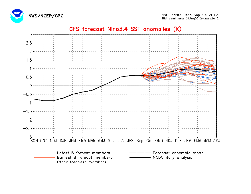
Taking a quick look at the El Nino Southern Oscillation outlook for the winter season and it seems like we will have a weak to moderate El Nino in the Pacific which typically means increased precipitation for the region. Yet another signal that's making me very concerned for this winter.
Last year I forecasted an average winter season in respect to snowfall and temperatures and it came out to be a decent prediction. There have been years where I was wrong, last season was not one of them and I like to believe that I'm gaining more knowledge with the years. At this point the winter season looks to be below average temperature wise and above average snowfall. Of course I have a lot more work to do before I can say anymore.

Get those shovels ready...

Monday, September 16, 2013

What are the poles doing?

Just a quick update about the sea ice. The Arctic Ocean has reached it's minimum sea ice for the summer and made a remarkable rebound from last summer in extent and thickness.


What does this mean for our winter? Well, it's still hard to tell. Many different factors go into a winter forecast but with the current ice extent it would increase the odds for a colder snowier winter in the northern hemisphere (not region specific).

Now looking at the Antarctic ice extent we can see clearly that over the last 30 years it's been growing and still holding very strong despite theories of global warming.


While my confidence in the winter forecast is becoming slightly clearer, it's going to be another month before I issue any kind of preliminary monthly forecasts.

*All images from http://arctic.atmos.uiuc.edu/cryosphere/