Wednesday, December 30, 2009

Some snow for New Years

A storm will come up from the south and brush over the area bring a complete snow event to northwest Jersey (No Mixing). Higher elevations will get more than the lower elevations because the temperature could hover around freezing. As of right now it's looking like 4-6 inches, check back tomorrow morning for a snow map.

Sunday, December 27, 2009

Friday, December 25, 2009

Arctic Oscillation Spells Trouble
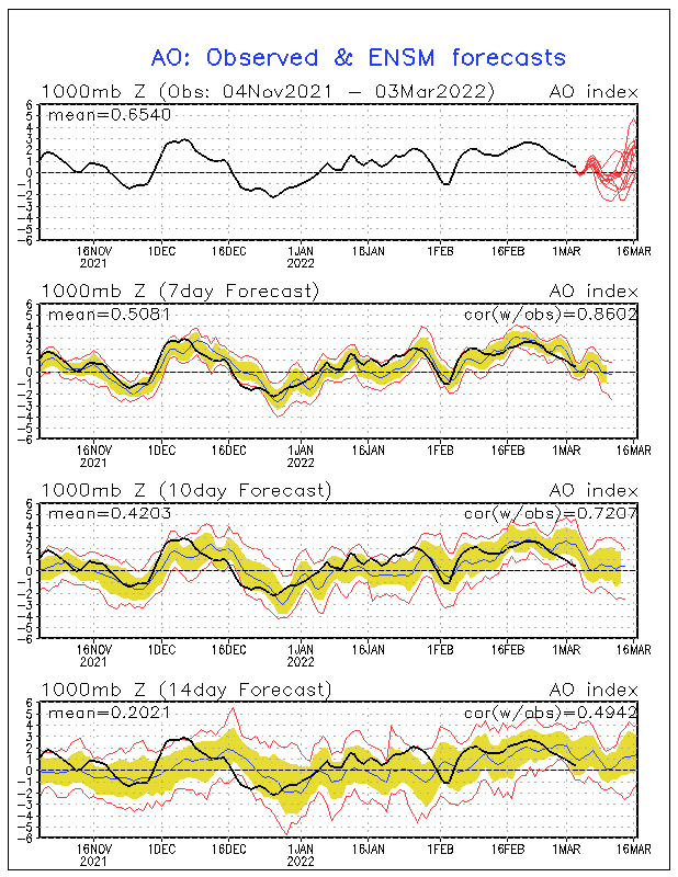
The latest AO forecast is off the charts. Since I have been into the weather I have never seen it go off the charts, and for so long. This signals one thing, extreme cold. When the AO is negative it means the cold air over the poles is easily transported to lower latitudes, and it's not polar air it's pure arctic air. To me this is a precursor of nasty times ahead.

This coupled with a negative NAO sends all the cold air into our region. After this winter I don't want to hear a thing about global warming, and neither will you. Check it out, it's almost unreal.


This intense blocking pattern over the arctic circle could be due to volcanic activity injecting sulfur into the stratosphere warming it which in turn cools the troposphere. The basis behind the AO! But that's only theory...

P.S I ended my below freezing streak with 225 hours and 32 minutes consecutive. (Not bad for December)

Thursday, December 24, 2009

Winter is just starting...

It's been 204 hours and 6 minutes since my weather station has recorded above freezing temperatures. Today will mark day 12 this month without getting above freezing but should be the end, for now. Most places in New Jersey have received around 2 feet of snow so far this season putting most areas from central Jersey and south ABOVE average for the entire season! It's day 19 of consecutive snow cover over northwest Jersey and the entire state will have a white Christmas, which hasn't happened in a long time. Philly, DC, Atlantic City, Baltimore, and most of the south is now at or significantly above seasonal snowfall. Resorts like Mountain Creek have been able to open terrain like it's their job. Four peaks in a week and two days at Creek? That's never happened in all my years and they should be in full operation by New Years, which is just mind boggling. The nation is now facing it's third blizzard in two weeks, and in Europe over 80 people have died from the extreme cold. Guess what. Extreme cold is coming next week and it's going to smash the records that have been around for 150 years. And you know what? Winter just started 3 days ago..

It's on folks...


P.S. Christmas Storm looks icy but look what is on the maps for New Years, the nations 4th blizzard in three weeks?


Saturday, December 19, 2009

From Vermont

Well I'm in Vermont, and it's currently -2 degrees here in Rutland. Anyway I have very limited resources considering I'm on my cell phone so I can't do a snow map. But I can attach picutures so here it goes:

Case 1: Storm slides south (just by 30 miles) this means we get 2-4 inches


Case 2: Storm rides on "current path" and we get 4-8 inches with less north


Case 3: Storm comes 30 west of current track and we get 10-14 inches


Lets go with the 4-8 inches to be safe, but small changes either way will drastically change the situation. It's interesting... places in South Jersey might get up to two feet!

Thursday, December 17, 2009

Blizzard on Sunday?

The NAM is really going all out with this storm, and as of now it's the only one. As of right now the model is predicting 18"-24" inches with spots of 30". Could this be true? "Winds of 35 mph for three hours or longer with reduced visibility below 1/4 mile and moderate to heavy snow", is the definition of a blizzard and what the model shows is exactly that. Check back tomorrow morning, I'll post again before I head out for Vermont.

Saturday, December 12, 2009

Seven day for Mountain Creek

Well, I thought it would be a good idea to issue forecasts for Mountain Creek to see when snowmaking will resume and when natural snow will come again. As of now it looks like we won't see an accumulating snow event until possibly next Saturday, but it's still WAY to far out to confirm that.

Wednesday, December 9, 2009

It's going to be a snowy month

Well another 5.5 inches of snow fell this morning before the change over putting my towns season total at 13.5"-16.5" inches (elevation depending). And the current snow depth as of 6:00 AM is 11 inches. North Jersey season totals range from 10"-18" inches so far, and some places this winter (higher up) will get 80 inches of the white stuff.

We have two storms to look at. First one is Sunday and it is not a major event, but an area of 2-4 inches could cover part of our area. This is off the 6z GFS:

The second concern for snow is for next Thursday the 17th, it's still WAY to far out but it will dump a lot of snow somewhere. We just have to figure out exactly where that is...

Keep checking back daily, even several times daily. The weather is getting fun...

Tuesday, December 8, 2009

Snowmap for tonight

Here is the snow map for tonight's heavy burst of snow. Elevation won't play as big of a role this time around but it doesn't hurt in this scenario as temperatures will remain below freezing longer to allow the snow to accumulate. For each color indicated the higher end of the amount will be in the higher terrain and the low range in the valleys. After the snow it will turn to sleet, then freezing rain, and then just plain rain. Low lying areas will have the freezing rain longer than anyone else. That means Sussex Boro, Vernon Valley, Montague, and other low lying areas.


Monday, December 7, 2009

More snow!

It's going to snow again, but this time won't stay snow for the duration. As of right now the models are showing nearing an inch of liquid by 12z Wednesday (7:00am) as all snow. But let's count in for higher snow ratios and mixing as well, this time points further north will get more. And in some cases elevation will matter yet again, and that's just the temperature at the surface and if it allows the snow to stick. Right now it looks like 3-5 inches before the change over to rain, but most of the precip will fall as snow. So we will not loose our snowcover. Here are the soundings from Andover and Sussex airports.

Andover airport

Sussex Airport:

It's going to snow, and it's going to keep coming... Check back tomorrow for a snowmap

Sunday, December 6, 2009

That went well

Recap:

This past winter storm went exactly how I forecasted in my snow map, here all some snow totals:
Hopatcong- 9 inches
Netcong Heights- 8 inches
Jefferson- 6 inches

And this is why those areas get pounded every time, the elevation. This picture is taken at Netcong Heights looking down on my neighborhood actually. My towns season total snowfall is now 8"-11" inches depending on elevation, while Killington Vermont only has 20" so far.


And having that much elevation makes this happen often...


The outlook:
Right now it seems like winter is really setting in. It's 6:07 and already 24.4 degrees with tons of snow on the ground and we never did get above the freezing mark. Wednesdays snow to rain event will not be enough to melt the hard dense snow cover over the higher elevations, and lake effect snow squalls will come during the end of the week as well putting down up to a few inches in the higher terrain. By next Thursday Mountain Creek will able to turn on the snowmakers and leave them on for a week continuously. They will be able to open within a week.

Check back for updates, after all this is the only and therefore the "most accurate" source for North West Jersey weather. May many feet of snow fall upon you.

Saturday, December 5, 2009

So it does snow in NJ?

Current snowstorm:

Sitting at my computer right now I can look out my window and see the ground covered in already over an inch of snow. I was just in Roxbury about five minutes away and the snow was only sticking on cars and mulch surfaces, but in Netcong the roads (including major roads) are all covered as temperatures have fallen below freezing. Elevation between the two areas is about 500 feet, and it really shows considering the temperature dropped 4 degrees during my five minute drive. Elevation like always will play a key role. Here is my snowmap:


Snowmaking anytime soon:

Even though it's snowing and below freezing snow making is currently not possible. It is 31 degrees right now in Netcong with 85% humidity making for a wet bulb temperature of 29 and 27 is required to make snow. Of course it will get colder over night and within the next few hours the wet bulb will reach the required levels and the snow guns could go on with marginal snowmaking, but tonight should make for good snowmaking. Tomorrow high temperature shouldn't get above freezing in most areas so snowmaking can go all day at the summit for Mountain Creek and then again tomorrow night. This will not be enough to open the resort though, unless they have some tricks up their sleeves. I personally suggest just blowing large piles of snow and leaving them untouched (not groomed) because it looks like a rain storm next week and temperatures above freezing. This will make less surface area over the snow and won't allow it to melt as easy if it was all spread out, then next weekend snowmaking will resume and that will be the cold shot that starts off the ski season in New Jersey.

Check out the wet bulb chart for yourself-

http://www.snowathome.com/pdf/wet_bulb_chart_fahrenheit.pdf

Tuesday, December 1, 2009

Snowstorm will miss us :(

The past model runs have shown some BIG snows for this weekends storm, but now all operational models have gone to the storm going off of the coast putting down snow along the NJ coast, Cape Cod, and Long Island. But that's it. What a bummer! Snowmaking temperatures will prevail overnight this weekend, but not enough to open Mountain Creek, not yet anyway. I was actually thinking that December 12th will be opening day.

For now we need to deal with a massive rain storm that will ride up the coast tomorrow night into Thursday. Then the cold air moves in and a snowy and cold pattern will persist. Winter is finally going to set up...

P.S. This weekends storm is still kind of far out, maybe the models will shift the low west. Keep your fingers crossed!

Saturday, November 28, 2009

Snowmaking is in the forecast...

Things have certainly cooled off the past day or so now. And strong winds removed all the leafs from my yard (no need to rake). I know it's been a rough season to forecast so far, and it's been challenging. Especially when the forecasting models are not into agreement on anything. But the NAO and AO are now negative and thats going to be noticeable with cold air and storms riding up the coast about two times every week, and some may yield snow. But we don't want that right now, we want arctic air for snowmaking. And it seems like that will move in for the 5th of December and Mountain Creek should be able to open the slopes on Saturday the 12th (a week later than projected) which isn't too bad I guess.

Check back in because we have snow chances this week. All I got yesterday was fllurries :(

P.S. Killington Vermont has had 10 inches of snow since yesterday. Look at the pictures from today vs. the one on my blog yesterday.

Friday, November 27, 2009

What is happening?

Ok, so I didn't make a snowmap. Simple because I don't think anyone will be accumulating snow. But snow will be flying in the air today! Without a doubt. But we DON'T want it to snow. If it snows then when resorts want to start making snow they can't because the base will have a rough time holding up against the weather with a weak layer at the bottom. So let's get some REAL cold air first.

This picture is from Killington VT about five minutes ago. As you can see it's almost December and it's raining here and not a single drop of snow. It's not just us.

The arctic oscillation and north atlantic oscillation are both negative now and getting more negative. And it's cold, and we have been dominated by low pressure. But where is that arctic air we need to start blowing snow? It's not just Mountain Creek, but EVERY resort on the east coast is currently not operating. This will change now, starting from north to south, but the low elevation of Mountain Creek is going to hurt badly. I don't see a snowmaking window (reasonable snow making) any time soon. There can be some night this week that blowing could take place, but I really don't recommend it because it will warm back up during the day and rain storms seem to be in our future. I hope this moderate El Nino collapses soon, because this is so far is a typical El Nino pattern. I even remember El Nino years with only 8 inches of snow for the whole season, but that was the strong El Nino of 1998. Let's just sit down and try to not think about snowboarding... or it will eat you alive

Wednesday, November 25, 2009

Snow is coming

It looks like it will be snowing by the end of the week. The models are still not in agreement with each other making this difficult to forecast. Check back tomorrow for the snowmap

Sunday, November 22, 2009

NWA Conference 2009

Here is the video from the NWA conference in Norfolk Virginia this past October!


Wanna link to this video directly? http://hurri.kean.edu/~milliron/videos/nwa%20norfolk.wmv

Black Friday snowstorm 2009?

Euro and GFS show it. Let's keep our fingers crossed. Could next Friday be our first MAJOR snowstorm? Keep checking back for more, I'm all over this.

Tuesday, November 17, 2009

Just one week away!

There is without question a pattern change taking place middle of next week. This change is one that favors cold and snowy weather, and I'll tell you why. The arctic oscillation has a positive and negative phase. The positive phase is when the stratosphere over the arctic is cooler than normal which allows for a strong polar jet stream, which keeps all that arctic air bottled up. Then the negative phase which has a warmer stratosphere which allows for the polar jet to weaken and cold air can pour south. Well right now the stratosphere over the arctic is flipping from cold to warm which indicates that we have some blocking starting to begin, and that winter is about to begin.


This is confirmation that the arctic oscillation (AO) with be going negative. And that is what allows for arctic air masses to invade the mid-latitudes.

Now I am a bit obsessed with atmospheric and oceanic oscillation patterns. And this is my favorite blocking pattern of all, the North Atlantic Oscillation (NAO). When it is positive it's typically warm and dry across the eastern US and Europe. But when it's negative it means colder and wetter weather for both, and in the winter it usually signals coastal storms with snow. If both the AO and NAO are negative at the same time it has winter written all over it. And look at the NAO chart:

Oh yeah. This is the start of winter, and I see snow making opportunities up and down the appalachians and even natural snow by next week. Finally.

Sunday, November 15, 2009

Only a week off :(

Well my "Mid-Month" that I was seeing on the models never really happened. But Ida, which the models missed completely did happen. That bad news is, that we have to wait a little longer for winter, but only about week and a half. Thanksgiving will really feel like winter, and it's all winter from then out... this is it

More Later On

Wednesday, November 11, 2009

Let's do a rewind

Well, the models did an absolutely horrible job on Ida. So much that in one day the models showed two feet of snow, inches of rain, and clear sunny skies. This lack of understanding effects every event that comes after, because now the pattern is totally different. It's like the Butterfly Effect, and that basically means that one little thing has a HUGE effect on the world around it. After the models caught onto this the mid-month trough that was consistently being shown disappeared completely.

Now, I keep hearing people say that this is the effect of El Nino. And they are simply wrong. The El Nino (which is weak by the way) is out in the western Pacific and is going to collapse sometime in January. It's not the reason why it's been so mild, and here is why. The Arctic Oscillation pattern typically needs to be negative for the cold air to move down into the mid latitudes, the cold air will have to wait a little longer. Perhaps in time for this years late Thanksgiving.

Let's give the models a few days a catch on to the upcoming pattern. Having the remains of Ida on the grid is not helping the accuracy of the long range. We are so close...

Sunday, November 8, 2009

What a headache

Well as of right now I see no consistency in any of the models. Not only different models, but also the same models at different runs times. They are having such a hard time because of the tropical systems located in the Gulf of Mexico. Let's give the models a day to become more organized and be trust worthy. I see anything from a snowstorm at the end of the week, to sunny skies, to a warm rain event. That's how poorly the models are handling this. It's going to be a tough week...

Saturday, November 7, 2009

First major snowstorm?

Don't be alarmed by the title, it got your attention though, didn't it? The 12z GFS has it on there and it's bring measurable snowfall Thursday-Friday. This wasn't on past runs, and I like to see consistency before I take a stand on anything.

Now as for my mid-month, the models have all but lost it for the past week now. But I know they are wrong, and todays 12z model finally has it back on there. More updates later tonight if the models become consistent.

Wednesday, November 4, 2009

Snowmap!

Well, this probably didn't deserve a snow map. But it does look like some light snowfall could occur over the highest terrain. The 1,000 foot mark is looking good for minor (very minor) snow accumulations. I normally wouldn't make a map as pointless as this but I'm getting excited for winter. Anyhow it's not a major storm so please don't get excited, not yet...

Monday, November 2, 2009

Snow and cold coming

One thing I have been talking about lately is a "mid" month arctic blast which will allows most resorts to open up early. Now that will happen around the 15th-19th, but let's talk about a closer event, one that yields more snow for the area.

This week a trough will dig into the northeast for the better half of this week and it will bring chilly, and yes snow. The snow flakes will indeed be flying in the air this week but it looks like southern New England and even into New York could be seeing the heaviest precipitation. The models keep tracking the system further and further inland, which would benefit us for accumulations. The trough will have a negative tilt and that is key in BIG snow, let's see if anything evolves out of this interesting situation...

Saturday, October 31, 2009

Tis' the season ;)

Mid-November will be more like late December as a strong Polar Vortex moves down from Canada. Classic negative North Atlantic Oscillation, so watch for development as well. It's going to be an early ski season from the Smokies, Allegheny's, Poconos, and Catskills as long as they use this snowmaking window wisely. It's coming...

Arctic blast looks more likely everyday....

This is all I have to say. The NAO and AO supported it yesterday, now the model is finally showing it. If this does indeed happen, then Mountain Creek will be able to open up for Thanksgiving. Keep checking back in, the winter pattern may be less than two weeks away.

Friday, October 30, 2009

AO & NAO

Both the Arctic Oscillation (AO) and North Atlantic Oscillation (NAO) are forecasted to tank around the 5th of November. This won't supply any adequate cold for cost-efficient snowmaking for the resorts of New Jersey but it could be a sign of things to come. In mid November those snow guns will finally get their opportunity...

Come back daily to check on the graphs above, they update automatically. Negative means cold and snowy this time of year, just remember that.

Thursday, October 29, 2009

The Polar Vortex

There is some hints of a true arctic front moving in mid November. It's a little far out right now, but let's keep an eye on it. It could be a worthy event for snowmaking up and down the entire east coast. The bigger mountains in the northeast will turn their guns back on next week, and that will lead to their opening. Check back every day or so for more information.

Wednesday, October 28, 2009

Snowmaking

It's almost November already and that means the eastern ski/board season is just about here, but living in the east coast means the snowmakers got to get to work. Next week will give places in Vermont, Maine, New Hampshire, and New York the required wet bulb temperature required to crystalize water droplets. But a strong enough cold shot is not in the foreseeable future for Mountain Creek or other area resorts. For now, the snow guns are just waiting. Waiting for the air and water to start pumping through the pipes.

When I see our first true arctic blast, one that will provide a decent snowmaking window, I will let everyone know a good week or two in advance. Enjoy what's left of fall, cause late November could get interesting...

Thursday, October 22, 2009

Winter 09-10 Forecast

After hours upon hours of going over the climatology records, looking at past years, investigating current trends in the atmosphere and oceans, even some math (which Im not good at), and using some personal knowledge I think I have somewhat of a good idea what is in store for this winter season. You may want to go get some hot coco and a pastry before you start to read this, because it is kind of long.

Let's first take a look at what I believe to be one of, if not the greatest influence on our winter patterns, the ENSO, or as most know it the "El Nino Southern Oscillation". This image actually updates on its own so you can always come back and check it to see what is going on. As of right now (Early October) we have a weak El Nino which is becoming even weaker, more toward a "neutral" phase. Take a look for yourself:

In the past years we have been in a positive phase of the ENSO know better as "La Nina", but that has finally ended. In those years we have a lot of freezing rain and sleet, and that was a direct cause of the La Nina because it pumped up a lot of upper level warm air which melted the snow in the upper atmosphere and refroze either at the surface or just before. Last year northwest Jersey picked up 45"-65" inches of snow (elevation depending) with a weak La Nina and our snows where still affected by a decent amount of ice. And the year before that with a much stronger La Nina brought 25"-35" inches, and A LOT of ice. I actually remember somestorms dumped 6 inches of pure sleet! Several times! And that really lowered snow totals, this year, it's not going to be an issue :)

What about this years ENSO phase?
"El Niño is expected to strengthen and last through the Northern Hemisphere winter 2009-2010." (From the climate prediction center)

Now I realize that I am not a climatologist, but I strongly disagree with the CPC on this, and I have good reason. For one they are forecasting a somewhat strong El Nino to form throughout the season but in the past month has totally reversed from what they were forecasting. Take a look below, does it look like it makes any sense? It doesn't... This is why I'm forecasting a neutral phase in the ENSO if not slightly positive.
This is what they were forecasting: (Sorry for the poor quality. If you see where it first starts to rise thats where the rise was in the image above. That strong el nino forecast had it very strong for mid October, but look above. It went down.)


The Pacific Decadal Oscillation?

The PDO is cycle that goes on in the northwest Pacific Ocean, along the Alaskan and Canadian coasts. There is a positive cycle and then a negative cycle. See below:


Unfortunately I am not as familiar with the PDO as I should be so here is quote from Accuweather's Joe Bastardi:

"My latest evaluation of the state of the Nino finds the only negative value is the global atmospheric angular momentum, which is the great regulator of the pattern. Its negative value acts as a cap on how strong this can get, which is borderline moderate for the start of winter.

The recent crash of the SOI means this will intensify. This is a crucial aspect of my winter forecast as the warming of the ONI areas means the PDO will warm, and a warming PDO in the heart of the cold overall PDO (multi year, multi decades) has led to some interesting winter implications. As important, it means the Mei analog to 1951-1952 will fall by the wayside"


The North Atlantic Oscillation?

The North Atlantic Oscillation or NAO is the most important pattern you can look for when forecasting weather events in the Northeast United States all the way to Europe. Typically the weather in the northeast seems to be a carbon copy of what's going on in across the north atlantic in Europe. Now I would get into detail but I need to shorten the blog so if you are not educated in the NAO check the link: http://www.cpc.noaa.gov/data/teledoc/nao.shtml

When looking at the NAO a negative phase means cold and snowy conditions while a positive is the opposite. This is a live image so you can always come back to this blog and check on its progress, or check out the same links on the right hand side of this page.


How much snow?

This is my general idea of this years snowfall totals. Just please note that not all colors are in intervals of 5 inches, several are a span of 10 inches. This is based on a 150% above normal snowfall. NYC will finally get above 40 inches and the ski areas of Sussex County like Mountain Creek, Hidden Valley, and High Point XC should get upwards of 80 inches + at the summit. It's going to be a great year!


THE OVERALL FORECAST FOR WINTER 09-10
  • Neutral Phase to slightly + ENSO
  • PDO will turn warm mid winter
  • Look for negative NAO values
  • Means colder and snowy conditions
  • Snowfall 150%+ of normal
Now I'm not going to try and forecast month to month, but at the beginning of each month I can attempt an "overview" of what is to come. This winter will be noticeable different than the previous ones in past years, this time expect mostly snow events and ice may be a thing of past until La Nina develops again. Wax your boards and take the ski's out of the basement, it's going to be an amazing season. That is if you like powder anyway...

Saturday, October 17, 2009

NWA Conference

I will be at the NWA conference in Norfolk Virginia for the next week so depending upon whether the hotel has free WiFi controls my blogging. Ill try to blog if anything exciting happens, but after this weekend it looks like things get boring.

You also might wondering why I haven't blogged about this weekends storm. And that's because I just don't believe much snow is coming. The soundings are just showing me that the atmosphere won't be able to support much frozen precipitation. You need to live high up to get accumulations with this one. There is always the possibility that all models could be wrong, I'm wrong, and we get 8 feet of snow. But I doubt it, winter is still coming.... :)

Wednesday, October 14, 2009

Check out this map

This is the predicted snow cover 36 hours from now: (Bull's eye over Sussex)

Snow swath shifts east?

This is from the 00z NAM (just came out at like 10:40 PM). Anyway, it's now bringing in the colder air and heavy precipitation into our area. If this stays consistent by tomorrow morning then expect heavy snowfall. Check back for updates sometime tomorrow.

First snow of the season?

Yeah, that's right. It's going to snow across the higher terrain of Northwest Jersey in October yet again! The issue is that the area is right on the edge of the rain/snow line so I don't expect any accumulation at the lower elevations, as of right now that is. Sorry Newton, Branchville, Vernon Valley, Sussex, and the rest of the central valley in Sussex County it's not your storm. If you live along the High Point ridge then expect accumulating snowfall and that goes for the highlands from Mount Olive, Hopatcong, Jefferson, and up to West Milford.

As of right now it's hard to tell how much snow will pile up, and that reason is because if it's 31.5 and snowing then your in good shape, but if it's 32.5 then you may have some issues. That's just how early season snowfall works. Places like Mountain Creek will be snow capped and that could lead to downed trees if the worst case scenario happens. And after last years ice storm, that is the last thing they want.

This is what the latest NAM is showing for the surface for Friday at 2:00 A.M:

Saturday, 8:00 AM

Now let's move to my smoking gun of the storm. The atmospheric soundings. Now imagine this as a vertical model of the atmosphere, the surface is 1000mb and then pressure decreases with height. Now look at the two white lines. The one on the left is dew point and the other is temperature. The first thing you see is how the two lines seem to merge together, this tells you the atmosphere is saturated and can really support heavy precipitation. Ok, no big deal, that even happens in the summer. But look at the bottom of the Skew-T, you see those blue numbers? That's surface temperature in Celcius, and it's forecasted to be right on the freezing mark. That means the atmosphere at Andover Airport can support snow at an elevation of 583 feet, if you like at 1,000 feet things could get interesting. And at 1,500 feet, prepare to potentially shovel...


It's going to be a close call, and if you get A LOT of snow don't be surprised. If you get no snow, don't be surprised either. Local conditions will vary and the usual "snowy spots" will yet again be the big winners.

Check back for more updates, I'm in winter storm mode...

Monday, October 12, 2009

Year without a summer, and a year without fall...

This is quoted from Joe Bastardi on his blog this afternoon. It's something that has been something I have been watching and we might get another major October snow event, and elevation is crucial. This winter is going to come early...


MONDAY 4 PM

"MAYBE NOT THE YEAR WITHOUT A SUMMER, BUT MAYBE THE YEAR WITHOUT A FALL FOLIAGE DISPLAY.

It does not take much wet snow to fall a tree still full of leaves. Late last week I started opining that there could be one heck of a winter event in the interior northeast... and it will be an event in the I-80 corridor in the plains and midwest, but for the northeast above 1500 feet from WVA to New england there is more at stake here as the period Thursday pm into Sunday could bring 2 wet snow events as a major trough pivots through the northeast with 3 separate storms over a 5 day period. The one in the middle, For Friday, should just turn into an out and out noreaster but at this time of the year, there is so much warm air around, that storms can develop quickly back near trough axis and so a second weekend storm may follow.

So here is the deal, if you live above 15 hundred feet in Pa NJ, New York, and New England I would be concerned you have enough accumulating snow to have trees breaking around you. That goes for Maryland too and into the central high ground of WVA> but the fact is it snows at this time of the year more often in places like Beckley and Bluefield so its not as big a deal."

Sunday, October 11, 2009

Latest Fall Foliage Update

This is from the Fall Foliage Network:


As you can see the state is very diverse when it comes to color. You have some areas where the color is low, to places where the color will most likely peak in the next few days. Surprising, the elevation really matters. Tomorrow I will get some pictures of mountain side in the Allamuchy's and the top of half is at peak color, where the bottom still has a lot of green. And that is representative of pretty much the whole northwest corner of Jersey. Updates tomorrow.

I have also been working on my winter season forecast. Which is really long right now, sorry about that. It's almost done and will be posted in the coming week. And I'll also be talking about how our first snow could just be days away.

Sunday, October 4, 2009

Cold snap coming, with snow?

As of now all of the long range weather models see a cold shot coming down out of Canada and a storm coming up from the south. Each one is most certainly showing snow for most of the northeast, even in the big cities. The GFS, CMC, NOGAPS, and EURO are all having the same idea and are staying consistent. There is a possibility of snow, but as of right it is unsure what will happen on October 12th.

GFS model:
Euro model:
NOGAPS Model:
CMC model:


Check back in tomorrow for latest updates to see what evolves out of the models!

Saturday, September 26, 2009

Fall is here, and its going to feel like it

This is my first blog of the fall season and on that note we should take a look at the current fall
foliage:


Most of the state has little to no change but the northwest corner is showing up 30% color and some of the deeper valleys and ridge tops are near moderate color.

Now let's talk cold air. Yes I said cold air. On Tuesday the 29th the strongest cold front of the season will bring the first freeze to most of northwest Jersey and points south will get their first frost. Now since harvest is still a few weeks away this could be a crop killing cold spell, and farms deep in valleys will suffer the greatest loss.

The cold spell will be at it's height on the first of October and will last at least five days. We may have seen the last of 70 degrees + days until next spring. The season is changing and that will be very evident in the upcoming week. Hang tight everyone Mountain Creek will open in 70 days, or maybe even less? Only time will tell. But keep checking back in cause if interesting weather is heading our way you can trust I'll be the first to let you know :)