
Tuesday, December 25, 2007
Is this the artic???

Sunday, December 23, 2007
Last blog post till the new year... its interesting
 (You can click on the map for a larger view)
Saturday, December 22, 2007
What is going to happen next?
Being the end of December the winter has been one of the coldest in recent memory and we are currently beating the past 10 years for season to date snowfall so far, very impressive. And not to mention 2007 will go down as the coldest year of the decade so far. Now that it is the first day of winter and we are all waiting for more snow and cold I have bad news, but maybe its not so bad?
Accuweather just put out their January forecast and it shows a warm month with very little chance of snow. Me being subborn won't go with that at all. The NAO is expect to tank again in early January and I have a feeling we will see a colder month than normal with these 2 or days of warmer temperature trends. These trends will be extreme and everyone knows on extreme leads to another of the opposite. If you want to get a good snowstorm you need to mix warm and cold air together because when the two airmasses collide with one another they create low pressure to balance them back out and bring things back to normal. Personally I see this last week of December to be a normal week temperature wise and some snow and rain will be around but nothing major, not that I see yet anyway.
The models are trending toward temps that are way to warm for any snowmaking but January could come in with a new weather pattern, one that trends with a few days of extreme warmth, then a massive system going from rain to snow, and then cold for a about week and that will repeat itself. It should be an interesting month and this is my personal opinion. And when the La Nina weakens at the end of the month winter will be in full force as the polar vortex over the artic comes down into Canada, the most of our cold and snow is still yet to come in February and March while January will not be so impressive.
Tomorrow will be my last post on potential snow until the end of the year because I will be heading up to Stowe Vermont! I can't wait :)
Sunday, December 16, 2007
It's not so bad!

Saturday, December 15, 2007
The January Thaw
As I look at the once great snowstorm for today I become upset. It shows all ice and then just plain old rain, and lots of it. Some people are mad at me for telling them that feet could fall in the matter of days, well I didn't. I look at the models and tell you what they are saying as of real time, nothing more, nothing less. The models are innaccurate and these are the same models used to forecast global warming 50 years into the future and they can't even forecast 2 days out. Funny, isn't it?
Friday, December 14, 2007
Light at the end of the tunnel?
 just won't happen, cause nothing works out for me...
Thursday, December 13, 2007
We get ripped off yet again...
As for this weekend, I am on edge right now. The track of the storm is the most important part and 20 miles either way will mean the difference between rain and heavy snow. I will post my final forecast for this weekend tomorrow night and I have a feeling we will all be let down, I have this strange vibe about it... Don't get bumbed out just yet, things can always change. I hope...
Wednesday, December 12, 2007
Update on both storms...
Now onto storm number two. This one will bring with it extremely heavy snow with possible sleet mixing the farther south and east you go. Wind will be a serious issue as well as blowing and drifting of the snow. This is a Nor'easter folks and if you don't know what that is, it is one of mother natures most powerful storms. It is too early to tell but if I was a guessing man I would 8-12 inches in areas that get sleet mixing in and 12-18 inches where it stays all snow. This means that by the end of the two storms the north Jersey snowpack could reach 18-28 inches and that is Vermont like boarding and skiing. I will let you know for CERTAIN by Friday night, keep checking back for updates!
I don't have time for any colorful maps but I will try to get some on later. Think snow! And head Mountain Creek tomorrow, I sure am....
Tuesday, December 11, 2007
The blizzard of 2007?
Between the time frame of Dec 15th-17th a major east coast snow storm is likely to happen but who, when, where, and how much snow is still unknown at this point. I am going to explain what will happen based off of the computer models that came out at 18UTC, Tuesday night. What I am going to show you is still just a possibility and not certain, not yet so don't get your hopes up.


Friday, November 23, 2007
Snowmaking begins!!!
As for some natural snow HOLD TIGHT!!! The last few days of this month and early December are looking really GOOD for snowmaking and coastal developement.... :0
Tuesday, November 20, 2007
Long range outlook Nov. 20th
After taking a short break from writing blogs I am back in action. The future for cold and snow looks upsetting to snowboarders and skiers but that's only according to the models. I am going to bring you through the models and we look from potential snow events and snow making opportunities.
A resort like Mountain Creek for example can't open with natural snow. They need to make their snow to build up their snow pack. It can be up to 50 degrees F and still allow for natural snowfall but in order to actually make snow they need to use the "wet bulb" temp chart. This chart takes the current humidity in the air and the temperature, all they need is a wet bulb temperature of 27. With 0% humidity snow can be made at 40 degrees! But we live in Jersey and humidity is much higher than that. With 100% humidity it needs to be 27 degrees outside before snow can be made, check out this chart to see what I'm talking about. Wet Bulb Chart
Now all we need is a few good days of low humidity and cold temperatures. Unfortunately I do not see that in our future. Up coming this Friday we should have a high temperature of around 34 degrees and snow making could be round the clock for around 36 hours but it's not enough to open up a resort. Here is the 18UTC NAM model for Saturday morning. I know it is hard to see but it is showing temperatures holding in the upper teens which are ideal for snowmaking. I think this is the first of snowmaking for Creek.

(The blue lines are the rain/snow line and each blue line shows different thickness values of the atmosphere which means how cold it is.)
As for snowmaking after this time period the models are not showing that to be a possibility, but I am going to risk my reputation and say that early December may be good for snow making. I am taking these computer models and throwing them in the garbage. There is just one thing that is bothering me, the NAO. The NAO is like a type of weather pattern and there are two phases, the negative and the positive. The positive phase means dry and warm weather for northeast U.S. and for Europe, while the negative phase is snowy and cold for both places. Just to show you how much this effects our weather the NAO was almost completely positive last winter and that is why it was less than ideal for riding. NAO also means that the east coast of the U.S MUST be watched for coastal storms or storms getting stronger as they hit the coast. Creek just got 6 more inches of snow Monday morning and guess what? We were in a slightly negative NAO phase. Keep your eye on this chart, when that red line goes negative expect cold and snow.
The thing is this winter according to some of the long range forecasters is NOT looking to very good snow and cold wise. They think that this December could be one of the warmest on record and that scares me. I am an optimistic person and I will doubt that until the time comes, I just don't see how things are going to be so warm at the solar cycle minimum right now and a neutral to slightly negative NAO forecast this winter. I am no professional yet (not until I finish college) but I think these others ideas of our weather are wrong, this is my gut instict and not set in stone just yet. Time will tell....
SNOW:
As for snow!!! I don't see anything major yet except for some lake effect possible on Friday but keep checking back for updates.
Tuesday, October 16, 2007
This is quite interesting? Don't you think?
Doesn't this fit much better than C02?

Notice how in 1996 low NAO made it a colder year, now look at 1998 NAO peaked and its the warmest year on record? Hmm... Interesting. Too bad the NAO records only back to 1948. If you find that shocking the artic and anartic ice records are only 27 years old. How do we know 1934 (new warmest year on record) didn't have a record minimum ice extent?
Does C02 fit the temperatures better?
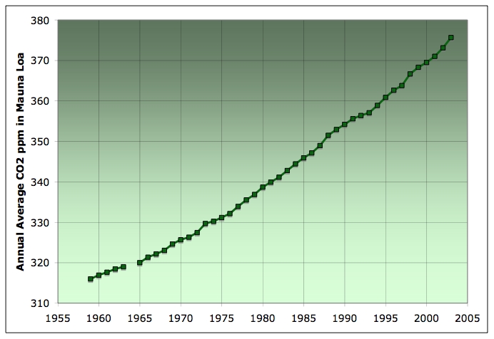
(I would say not.)
Whats with the 800 year lag in C02 after temperatures went up?
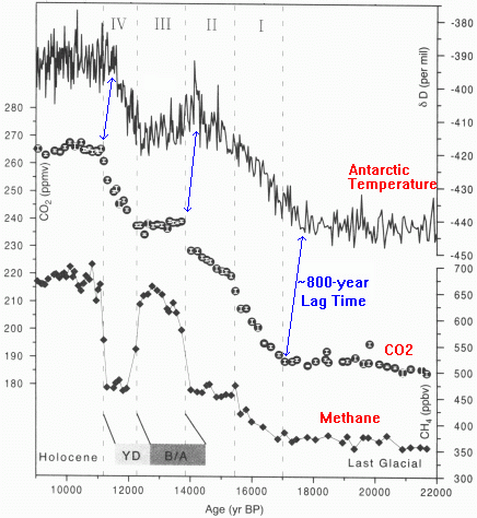
Ill give you the reason why, Anthropogenic Global Warming is a lie and it a phase. Come on! Man made C02 makes up a fraction of a fraction of the atmosphere and allows plants to grow healthier and bigger! C02 is also one of the weakest greenhouses and water vapor and methane are the strongest of them all. I know, let's tax water vapor! That should stop global warming.
Sunday, October 7, 2007
Pattern Change!
The NAO and AO are something I talk about all the time because they are the two key players in our weather here in North Jersey. (http://meteomaddness.blogspot.com/2007/09/snow-watch.html - go to that old blog to learn more about the NAO and AO) Both of the two are currently taking a nose dive toward the negative side and the weather will certainly take a nose dive along with it. The negative phase means cold air/low pressure for our region, just to give you a heads up, last winter was mostly a positive phase.


Let's get to the models! First model is the DGEX which is a downgraded form of the GFS. This shows the forecasted temperatures 150 hours out. As you can see from the key White is 0 degrees C, which is 32 degrees F. (First freeze!!!!) (MAP OF DATE, SORRY)

The next model is the NMC. Most know it as the spagehtti plot. It too shows cold air and if you want to see the animation click the link. http://www.cdc.noaa.gov/map/images/ens/spag_nhsm_animation.html
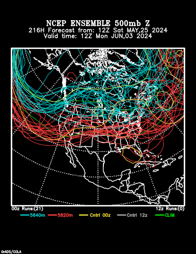
The GFS model is the last but not least. The 18 UTC model just came out and is showing some days where we won't even get above 50 for the day! Im not going to post the image itself, just click the link to look at the model run! http://www.nco.ncep.noaa.gov/pmb/nwprod/analysis/namer/gfs/18/index_slp_lu_loop.shtml
FALL FOILAGE!!!
The leaves are delayed a bit but they should peak in the next 8 t0 10 days! Check out the link for the Fall Foilage Network... http://www.foliagenetwork.com/reports/northeast_us/
Thursday, September 20, 2007
I spy the first snow...
The model that just came out forecasted nearly 16 days out and I would consider all of the information that far out USELESS. I'm just letting you know that this isn't exactly what will happen but it is giving a general overview of the future weather pattern. These models below are not accurate but it is Oh so fun to look at them.
This model below is for Friday October 5th, (GFS). This shows the temperature dropping nearly 40 degrees during a cold front with a rain changing to snow event, if this happened we could have our first accumulating snowfall of the season. (remember this is REALLY far out so things can and will change)

The next model is for Saturday the 6th of October (GFS) and it is showing high temperatures in the upper 20's with lake effect snow squalls. If this happened I think the local ski resorts like Mountain Creek could test their snowmaking system out. I'm not sure if they would do so this early in the season though. I do believe the first freeze is imminent though. (remember, this is FAR out so don't hurt me if it doesn't happen)
If you really care about this stuff keep an eye on the NAO and AO, if anything changes with those two then you can bet the models will change as well. The NAO and AO can be found below, they update daily by themselves. (If you don't know, the black lines show the past record of blocking and the red lines show the forecast)


Tuesday, September 18, 2007
Long range forecast...
The next week should be August like and will be very NICE! We could even see one or two more days of 80's but after that we are done with 80's till next spring. So enjoy it! There is something very interesting that is making me go back to an old saying I use during the winters months "One extreme leads the another of the opposite". I believe that will most certainly happen too. It will be warm and dry for the next week and half to two weeks but then in time for October things will change dramactically!
The NAO and AO are types of high latitude blocking and if current projections are correction they will both tank in two weeks time. This will bring cold and weather pattern with it to the eastern US and maybe the first freeze event of the year. The models are not showing this yet but I bet they will in a couple days. Below is the link, check it out!
http://www.cpc.noaa.gov/products/precip/CWlink/pna/nao.shtml
I know I said I would do a fall foilage blog but nothing really has changed just yet, I will be doing one in coming days.
Friday, September 14, 2007
Snow watch!

Now we can move on to better things, one step at a time. North Atlantic Oscillation or (NAO) is a key factor in northeast snowstorms. In fact its the main ingredient as Paul Kocin would say who literally wrote the book on northeast snowstorms. Here is a link about NAO, its short and easy to understand. http://www.ldeo.columbia.edu/NAO/ . As you read in there a negative NAO is what we look for when praying for coastal development, we are currently in a 30 year positive phase but in the last couple months we have struggled to get positive, maybe this is why we had a cool summer? This NAO is a very easy concept. Right now it is neutral to positive.

Now that we know the basics of the northeast snowstorms let's go to the models! The GFS is the only model right now that I have access to that is showing any signs of possible snow for here in NW Jersey, but things will most certainly change. This same model had a montana blizzard on it last week and showed cold air coming into the northeast, one of those two came true. Check it out, it doesn't actually show snow except for farther north. What if that cold push keeps coming down and that little clipper system brings precip? Hmmmmm? Lake effect too? Interesting.

That's all I have to show for now, tomorrow I will be posting a fall foilage blog to update you on the very latest. For those of you waiting for snow boarding season you might see this mountain snow covered sooner than you think!

Monday, September 10, 2007
Lake effect snow!
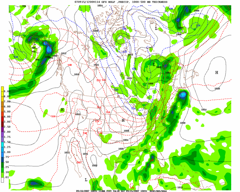
(GFS, 4 days out) Ok, so its no 15 feet of snow, but its snow! So early in the season too.
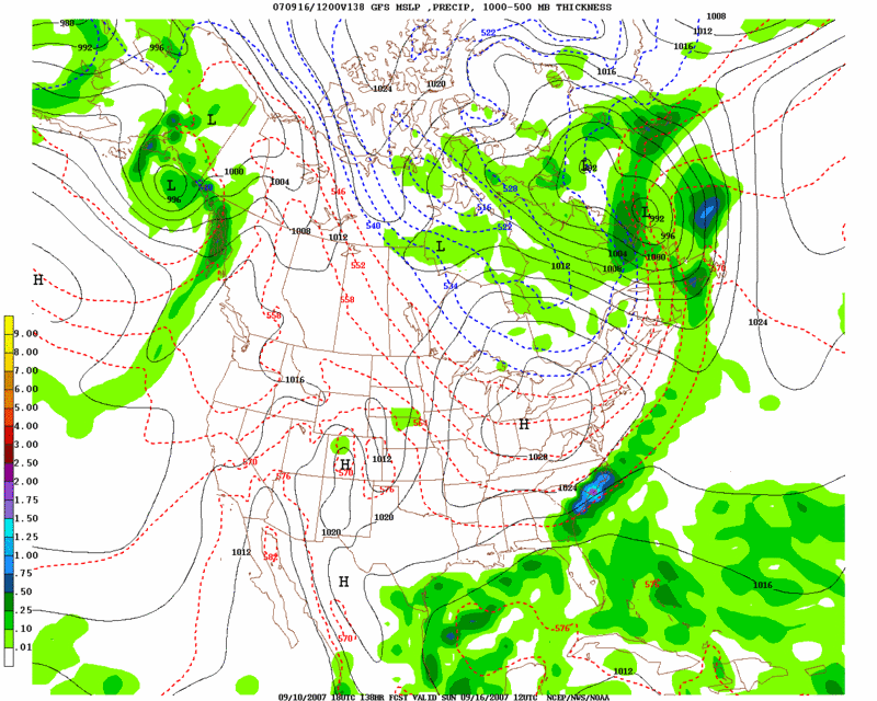
(GFS, 5 days out) If this happens, we can expect temperatures in the 50's for NW Jersey and 60's for NE Jersey!
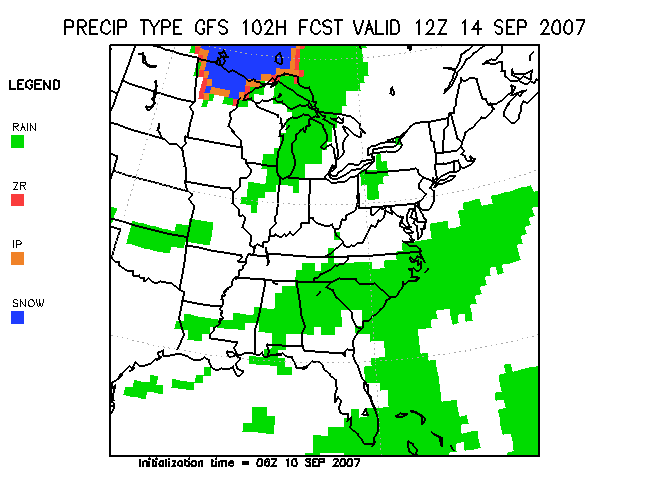
(DGEX model, 3 days out) Im lovin this one! Signs of snow!
Sunday, September 9, 2007
Winter 2007/2008 Outlook
The blog will contain two parts. The first will be the Old Farmers Almanac prediction and then my prediction for the winter season. Mine will be a general overview and explanations why it will be the way it is. The Almanac will go day by day telling you what the weather will be. Last years Almanac was almost completely wrong but other years it was right on. The Almanac is up to 80% correct!
THE OLD FARMERS ALMANAC- (Northeast only sorry)
September:
1st-3rd. Wet weather in New England. Farther south, scattered showers, thunderstorms Labor Day holiday.
4th-7th. Fair, pleasant.
8th-11th. Hurricane threat for Mid-Atlantic and Northeast coasts. Thunderstorms sweep in from west, then clearing.
12th-15th. Fair skies.
16th-19th. Rain, then turning fair, coolers.
20th-23rd. Fair skies persist.
24th-27th. Thunderstorms rumble rapidly across region, then clearing, cooler conditions.
28th-30th. Fair skies, then scattered rain showers.
October:
1st-3rd. Mostly fair.
4th-7th. Dry, windy weather.
8th-11th. Strong disturbulance sweeps east, with heavy rains for mid atlantic states. Stormy with gale-force winds (39 mph +) along New England coast.
12th-15th. Showers reach NY, Penn, and Northeast, accompanied by milder air.
16th-19th. Dry, milder, especially New England.
20th-23rd. Severe thunderstorms move in from west, then clearing, unseasonable cold, widespread frost.
24th-27th. Fair at first then turning unsettled.
28th-31st. Fair for trick-or-treaters.
November:
1st-3rd. Fair skies.
4th-7th. Stormy weather developes over mid-atlantic states, early season snowfall possible then clearing, cold. Gusty wet for ING New York City Marathon.
8th-11th. Light snows rapidly sweep into New England.
12th-15th. Fair skies persist.
16th-19th. Squally condtions into mid-atlantic states, stormy New England, then clearing, much colder.
20th-23rd. Weather deteriorates by Thanksgiving. Fair at first, then turning wet, with rain mixed with snow in New England. Cold with rain Virgina, Maryland.
24th-27th. Mostly fair, cold.
28th-30th. Generally fair weather.
December:
1st-3rd. Snow falls from the mid-atlantic states to New England, then clearing.
4th-7th. Becoming unsettled.
8th-11th. Cold and dry.
12th-15th. Another snow storm, with significant accumulations as far south as Maryland and Virgina. Then fair, cold weather.
16th-19th. Mostly fair.
20th-23rd. Snow from Penn, New York, to Maine. Then fair.
24th-27th. Dreaming of a white Christmas? Snow possible most areas.
28th- 31st. Stormy through New England, with a heavy, wintry mix. Rainy mid-atlantic states, then fair, cold.
January:
1st-3rd. Unsettled. Showers in the Mid-Atlantic region, then turning fair and cold. Showers could fall on the Mummers Day Parade in Philadelphia.
4th-7th. Storm sweps through western sections of Penn, and NY, bringing gust winds and moderate-to-heavy precipitation.
8th-11th. Blustery and colder, with lingering clouds and scattered snow showers and flurries.
12th-15th. Mostly fair skies.
16th-19th. Wet weather, then turning fair and cold.
20th-23rd. Heavy snow for New England, with lighter amounts father south.
24th-27th. Most snow and flurries.
28th-31st. sharp cold front delivers snow and rain showers, followed by clearing and cold.
February:
1st-3rd. Fair skies.
4th-7th. A sharp cold front brings gusty winds and showers of rain and snow.
8th-11th. Unsettled, with light snow and flurries.
12th-15th. Some lingering snow shower of flurries through Penn and NY into New England, then fair.
16th-19th. some snow or rain showers.
20th-23rd. Blustery and cold winds.
24th-29th. A big storm evolves out voer the ocean, perhaps giving the coast a glancing blow with some light snow, then turning fair.
March:
1st-3rd. Fair skies.
4th-7th. Light snow or rain.
8th-11th. Showery weather possible, especially along the Mid-Atlantic region.
12th-15th. Scattered showers.
16th-19th. Unsettled weather, with mixed rain and wet snow, and gusty winds.
20th-23rd. Coastal storm brings more and precipitation for the very early Easter.
24th-27th. Shower for Virgina, Maryland to New England.
28th-31st. Yet another coastal storm! More wind, rain, and snow.
MY WINTER OUTLOOK:
This might sound very boring to you but winter is likely to be a cold one across the northeast and this is because of a La Nina out in the pacific and we are at the end of the 11 year solar cycle, this mix with the right phase of high latitude blocking (NAO) spells coastal storm after coastal storm. Last year looked like a bad winter too but a El Nino developed and the first half of the season was rather pathetic.
Weather is a big cycle and the last time we were at the minimum solar cycle (95-96) NYC had over 80 inches of snow! That winter also dumped snow so deep in my yard here in northwest Jersey that my four foot pool was missing and the cars were blocked by 10 foot drifts! Let's see if winter makes a repeat of this great season.
This summer ended below average this year with
- 4 days of record low highs
- 4 days above 90 (way below average)
- 0 record highs
- high of 57 on 8/22 (october average)
- Science proved 1934 was hottest year ever (not 1998)
- Parts of Greenland never got above zero since last summer
I had much more of my outlook but the farmers almanac with was "unexpected" took the responsibility of being wrong off my head. Thank god. Cold weather and snowy conditions can be expected though. The artic is already losing 23 minutes a day and cooling down rapidly. Expect snow blogs to start SOON!
First Entry, the season begins.
North Jersey is one places that expierences the "4 seasons". My personal favorite time of the year is September-April. I live in northwest Jersey myself and I may tend to focus on weather here than the weather in the east, and I am sorry about that one. Weather can be quite different from where I live to near the city. In fact, the temperature is 4-8 warmer there than it is here. I am a global warming skeptic and trust me, I can put up quite an argument. Here are some of the things I will talk about in this region specific blog:
1. Fall foilage (from the fall folilage network)
2. Climate change debate
3. Northwest Jersey weather
4. Northeast Jersey weather
5. Model hype
6. Local ski resorts
7. Snow outlooks
8. Whatever else I find interesting
First blog entry: (Fall foilage)
September 8 , 2007
Welcome to the 2007 foliage season! Labor Day has passed, marking the unofficial end of summer and the beginning of our coverage of the fall foliage. This is The Foliage Network's ninth year covering the foliage in the Northeast.
The summer temperatures in the Northeast U.S. have been, on average, close to normal with departures from normal ranging from -2F to +2F. In portions of southern Vermont, western New York, northwest Pennsylvania, southeast Pennsylvania and southern New Jersey, it was slight warmer, with departures from normal in the +2F to +4F.
Analysis of three month (June-August) precipitation in the Northeast is also very close to normal, on average. A few areas of note include the Adirondacks in northern New York where the 3-month period was exceptionally dry (2.00" of precipitation or more below normal); moderately dry (0.80" to 1.29" of precipitation below normal) conditions in central Maine, southeast Vermont, western New York, central Massachusetts and portions of central Pennsylvania. In contrast, it was moderate moist (0.80" to 1.29" of precipitation above normal) in coastal Maine, northeast Vermont, southwest Pennsylvania, northern New Jersey and Long Island, New York. Also of interest is the month of August, in which much of the Northeast was very dry. Let's hope we get some rain in September.
There is not much yet to report, as expected, at this early date in September. However, there have been reports of the typical early color in some young and distressed trees and in some of the "show-offs" which are those trees that change earlier than others on an annual basis. This is no cause for alarm and is not an indicator of early change. There have also been reports of many leaves turning brown and falling from walnut and poplar trees. Again, no cause for alarm as these species are not widespread in the Northeast.
This information provided by Marek D. Rzonca, The Foliage Network.

Here is a picture to show the current fall foliage in Northwest Jersey: (Not too much going on)


