Thursday, December 30, 2010

The Storm....

The past storm really hit some places hard with over 30" inches of snow toward the city, but western areas likes Phillipsburg picked up just 3.5" inches. The snow map I issued was over done to the west and underdone to the east, typical of convective bands of snow. Morristown at one point was getting 4 inch and hour rates with thunder and lighting while I was getting light snow. To make it worse I only live 20 minutes from there and I watched the band of snow stall out just a few miles from my house!

Here are some totals:

...MORRIS COUNTY...

BOONTON TWP 18.5 900 AM 12/27 COCORAHS

JEFFERSON TWP 12.8 600 AM 12/27 COCORAHS

HARDING TWP 12.0 700 AM 12/27 COCORAHS

PARSIPPANY-TROY 12.0 800 AM 12/27 COCORAHS

ROCKAWAY TWP 11.0 800 AM 12/27 COCORAHS

DENVILLE TWP 10.3 700 AM 12/27 COCORAHS

ROCKAWAY 8.0 800 AM 12/27 COCORAHS

MINE HILL TWP 7.2 800 AM 12/27 COCORAHS

ROXBURY TWP 6.8 700 AM 12/27 COCORAHS

MOUNT OLIVE TW 6.2 700 AM 12/27 COCORAHS

RANDOLPH TWP 6.0 700 AM 12/27 COCORAHS


...PASSAICCOUNTY...

CLIFTON 25.5 215 PM 12/27 TRAINED SPOTTER

HASKELL 24.5 200 AM 12/27 TRAINED SPOTTER

WAYNE 22.0 915 AM 12/27 TRAINED SPOTTER

RINGWOOD 22.0 810 AM 12/27 PUBLIC

WEST MILFORD 22.0 415 AM 12/27 TRAINED SPOTTER


..SUSSEX COUNTY...

HOPATCONG 7.2 1206 AM 12/27

NEWTON 7.0 837 AM 12/27

SUSSEX 6.0 1036 AM 12/27 CO-OP

LAFAYETTE 5.0 936 AM 12/27

HAMPTON TWP 4.9 144 PM 12/27

WANTAGE 4.5 413 AM 12/27


...WARREN COUNTY...

HACKETTSTOWN 7.0 935 AM 12/27

PHILLIPSBURG 3.5 1057 AM 12/27


You may wonder why West Milford is in red. And thats because it's a false report and the "trained spotter" who reports from there always has higher snow totals then everyone around him. Consistently!


There really isn't much weather to talk about in upcoming days. So I'm going to take a little break from blogging for the next two days and get my new weather station set up that I got for Christmas! So excited....

Monday, December 27, 2010

Well, that was interesting

The blizzard hit, but there was one sharp western cut off. At my house in Netcong only 8" of snow fell, while 10 miles east are topping 18" because of intense bands last nights. And just 20 miles east some areas are reporting 31.8". And central park is currently at 13".

Storm tally and update later

Sunday, December 26, 2010

Update on blizzard

Since yesterday I have no changes to my snow map. I want to stress how dangerous this storm is to everyone. Just because snow totals may not be as much as we got back in February, this system will be colder and produce a lot more wind! If you must leave your house make sure you have four wheel drive and do not go anywhere without making necessary preparations. Travel is discouraged!

In the event that you leave your home make sure to pack a safety kit. Water, flash light, shovel, kitty litter/or sand, blankets, food, and your cell phone are a must! If you get stranded in the storm don't not try to travel by foot! Stay in your car and notify locals officials of your location.

Map still looks good to me:

Drifts 3-5 feet could cause some roads to be impassable even by truck. Also colder temperatures will allow to the snow to stick much quicker to roadways and road salt will be less effective. Enjoy and be safe!

Saturday, December 25, 2010

Merry Christmas

As of yesterday morning all operational weather models were in agreement that the storm will go out to sea (OTS). Then the GFS at 12z showed a massive snowstorm along the eastern seaboard, and NCEP/HPC said the model wasn't initialized correctly. That basically meant to ignore the model completely. Then the 18z model came out and showed a similar scenario, and that began to raise some eyebrows. By Christmas morning all models (globally) went to the idea of a major east coast blizzard. Merry Christmas!

Take a look at the 18z NAM total liquid precipitation for the event:

Now I based my snow totals on this model only, and tomorrow I will make another snow map and adjust the forecast if needed. I mainly based it off the total precip (QPF) but also included the higher snow ratios in colder western areas. For every 1 inch of liquid 15 inches of snow will fall in western sections and 10:1 ratio toward the city. Here is my snow map, and no I'm not being conservative at all.

Any shift eastward or westward on the exact track can drastically change the total snow amounts. By tomorrow morning I should have a map that I'm finally happy with.

P.S. Just like last years blizzards, a major stratospheric warming event over the arctic caused the arctic oscillation to tank at record low levels. It just goes to show how weather somewhere else in the world affect us right here at home. It reminds me of the butterfly effect http://en.wikipedia.org/wiki/Butterfly_effect

Thursday, December 23, 2010

The Snow Drought

First off I want to apologize for not posting in the last couple of days. I've been busy working trying to get everything done before the holiday. Personally, you didn't miss much.

My last blog brought up the possibility of a Christmas snow storm. There are two problems with that as of now. First off the current system out to sea along the northeast coast is acting as a block slowing the flow and thus delaying the storm system. Second the delay in the storm system will allow for more bitterly cold air to attack the region sending the storm out to sea entirely. December will end with 0.4" of snow at Sussex Airport, thanks to an extremely cold and dry weather pattern.

Even with this practically snowless month Mountain Creek is having it's best start to the season in, well, ever. Natural snowfall doesn't help out resorts in this region to much, they rely on the man made snow. Real snow sublimates (evaporates from a solid to gas), melts faster, and disappears quickly in a rain storm. But the man made snow is more thaw resistant, rain proof, and makes for a better base. Now obviously natural snow makes for better surface conditions but thats all it's really good for, except for the mountains out west of course.

Here is a look at the Euro for the storm this Sunday:

After the New Year a pattern change will be in the works. One that makes for more mild and stormy weather. The problem is the storms will like to track up through the Great Lakes putting us on the warm side of things, but January will be more likely to give us some snow. I just can't believe December didn't provide us with one decent snowfall given the negative NAO and record negative AO. It just goes to show how different a La Nina season is compared to El Nino like last year.

P.S. Don't get bummed out just yet. While the best part of this storm will hit coastal areas and some fish out sea we may still get some light snow out it all. The storm is still 72 hours away, and things can and will change between now and then.

Monday, December 20, 2010

First Christmas Snowstorm Since 2002?

There is nothing like a perfect Christmas Eve by the fireplace, drinking a cup of hot coco, and watching the flakes fly. Will we all get that opportunity on Christmas? Well only if you have a fireplace, because the chance of at least some snowfall looks promising.

Currently the EURO, GFS, and DGEX are all suggesting a good dump of snow. They all predict around a foot for most of the state, but all we need is an inch for a white Christmas.

The GFS:

The DGEX:

The Euro:

Now some models like the JMA, GEM, and NOGAPS track the storm offshore. The event is still five days away and the models need a little time to get things right and come into agreement. It seems likely that places further east have a better shot at bigger snowstorm but if the track changes by just 50 to 100 miles then things could be very different. The difference between a major snowfall and partly cloudy skies relies on the exact track of this system.

I'll post tomorrow on the progress of the models and begin to make my forecast for the upcoming event. Make sure you all tell Santa what you want for Christmas, a SNOWSTORM!

Friday, December 17, 2010

The Void

I want to point out that our region is the only one with below average snowfall for the season thus far. In fact, we are the only ones without a decent snow event. Washington D.C., Cape May, Long Island, Virginia, Raleigh NC, and north Georgia are all ahead of us snow wise. Take a look at this sad map of current snow cover:

Will this trend continue? I personally believe so. In fact, after this weekend a 360 degree circle around us will have snow cover. This weekends storm looked bad to me all week, and I refused to jump on it. And it looks like that was a good decision because the storm will go out sea, missing us entirely.

There are several chances of snow after this weekend for our area. The first would be mid week, but that looks as if it could go south and give Washington another dump of snow. The second would be Christmas Eve into Christmas day. We just need to be patient, even I am becoming some what frustrated.

The good news is that the cold air has allowed the resorts to really pump out the white stuff and Mountain Creek is having their best start to the season I have ever seen. If we were in a snowy pattern we would probably be warmer which means the snowmaking could not be as extensive. In a way, things are working out well. Stay positive and stay tuned.

Thursday, December 16, 2010

European model changes it's mind

The Euro model is one the best weather models out there right now, and it shows a sizable snowstorm for most of the state come Sunday:

The only thing is, I don't buy it. Currently it's the only model showing this kind of solution and it could be just one bad run. I'm sticking with my little to no snow accumulation out of this weekends snowstorm. I could be eating these words by morning, but I just don't see it right now. I actually hope I'm wrong.

Check back tomorrow for final call and a snow map if needed.

Wednesday, December 15, 2010

Models in agreement now...

Once again the GFS was over done on this storm. It finally caught on to the idea that every other model has been seeing for several days. The storm looks like it will go out to sea.

It just goes to show that the United States has the least advanced weather models. We need to play a serious game of catch up to reach the level of the European model, or even the Canadian. Another one bites the dust.

After this storm I don't see any other major snow threats all the way up to January. This could very well be a near snowless December, and personally I give us less than 10% chance of a white Christmas.

I know we are all down in the dumps right now, but it's the weather! Things can change on a dime and we will get ours. The snow haters in the region can't be lucky all season...

Tuesday, December 14, 2010

Winter Storm Outlook

There are a lot of different weather models out there. Some are known to be notoriously bad, and others almost spot on. Let's take a look at a few of these and see which is the winning the model for our big snowstorm potential come Sunday.

1st up: GFS (Currently shows a 10"-15" snowstorm across most of Jersey)

2nd up: DGEX or extended NAM/ETA, same difference... (Similar to GFS)

3rd up: ECMWF or European model (Shows a storm going way out to sea, no snow)

I can go on for hours with different types of models. As of right now the only models showing a snowstorm on Sunday are the GFS and DGEX. They both run off of the same basics physics and computer program so I would expect them to be very similar. The odd thing is that the Euro, JMA, NOGAPS, UKMET, and CMC all have the precipitation just offshore from the Jersey coastline. Let's give the models another day or so. Will the GFS come out on top? Or will it bust like it did on the last event.

Sunday, December 12, 2010

The plunge

Our future for natural snowfall looks lame to say the least. We do have some possible chances in the coming week but as of right now it's way to early to get a grasp on it. After this nasty little rain storm expect sharply colder conditions for the rest of the week, with snowmaking temperatures 24/7. Mountain Creek and other local resorts may end up having more than half of their terrain open by Christmas. Impressive, but why?

We have had plenty of cold air lately, but almost no natural snowfall. This may end up being a cold winter which is not alway a good thing. Last winter was warmer than normal with copious amounts of the white stuff while previous years were much colder with half the snowfall. Why you ask? This is where I get a little advanced, so try to follow along.

There is short range forecasting and then long range forecasting. Long range forecasting requires a strong knowledge in atmospheric dynamics, oscillation patterns, and teleconnections. There are several patterns which directly impact the weather here in North Jersey:

NAO (North Atlantic Oscillation)
AO (Arctic Oscillation)
AMO (Atlantic multi decadal oscillation)
ENSO (El Nino Southern Oscillation)
PDO (Pacific decadal oscillation)
PNA (Pacific North American)
QBO (Quasi biennial oscillation)

All of these have a negative phase and positive phase, as well as "neutral" in between. Some switch phase weekly, biannual, yearly, and even every 30 years. Our negative NAO supplies us with stormy weather and cooler temperatures, and we have been negative! The problem is the La Nina which likes to track storms up the Appalachians and also the extremely negative arctic oscillation which is providing us with too much cold air dry air.

Current ENSO phase (La Nina)

Last year the AO went record negative. In fact the graph only went to -4 and the climate prediction center had to fix the graph to go to -6. Well, the AO may reach another record minimum in coming days.

The cause? Strong stratospheric warming over the high latitudes. The most impressive I've ever seen. Take a look at the animation, you can see the sudden warm up over Siberia.

You think it's cold here? For December it's very impressive. In fact parts of Europe are seeing the worst winter in several hundred years. I wish I knew why, but it could very well be the fact that our current solar cycle is the weakest since the Dalton Minimum in the early 1800's.

People are alway talking about how the winters here haven't been so good in the past 20 years. You here from your parents how bad the winters were "back in the day", and most people think of global warming. Wrong. For one the intense solar cycles of the 90's and 00's lead to warm decades. Also the AMO shifted into it's 30 year warm phase, and when it goes back to negative within the next 5 years expect winters similar to the 1970's.

We also have an unfavorable Quasi biennial oscillation phase. Every 28 months the winds in the stratosphere above the tropics shift direction from easterly (negative) to westerly (positive). Current we are positive which means storm track further inland and more intense hurricane season. The QBO was positive in 2005 as well when we had our record hurricane season. The La Nina, westerly QBO, and positive AMO means increase in hurricane activity. Not caused from global warming.

We still have a lot of winter to go. In fact, it hasn't started yet. Every winter brings something new and interesting. I'm sure this one will do the same.

Thursday, December 9, 2010

It's not our storm

Well, this blog is in response to yesterdays post. The GFS played it's usual games for day 4 out, and North Jersey will see primarily a rain event. The precipitation may start off as a wintry mix then go to a heavy rain for Sunday to end as snow on Sunday night. As of right now it does not look as if we will see much in the way of accumulation. It's just not our storm.

The good news is Mountain Creek is opening Saturday with 10 trails. At the rate they are going I wouldn't be surprised if they are 100% open by Christmas. That hasn't happened in the past 11 years I've been going there. After the rain Sunday snowmaking will resume around the clock for another week straight at least.

Creek's Forecast:

Monday: Snow Showers

High: 28
Low: 10

Tuesday: Partly Cloudy & windy

High: 15
Low: 4

Wednesday: Clear

High: 20
Low: 9


You wonder why my forecast is so much colder than any other site? That's because they adjust their forecast to climatology. So naturally it will be much warmer. For example NOAA forecasted 29 for a high today and the actual was 23, but five days ago they said 34 for today. That method of forecasting doesn't work to well in north Jersey, but it seems to work better in the city.

Not only that, but I live here in southern Sussex county. I know the weather here much better than some guy in Atlanta working for The Weather Channel or an employee at Mount Holly NWS who lives in south Jersey. In the end, my forecast it verify much better. And I think we should do a little experiment. Below I will post The Weather Channel and National Weather Service forecast for Mon-Wed of next week. Let's see who does better?

TWC:
Monday- 34/11 Rain/Snow showers
Tuesday- 22/12 Partly Cloudy
Wednesday- 24/19 Scattered Flurry

NWS:
Monday- 31/12 Snow showers
Tuesday- 23/11 Flurries
Wednesday- 26/14 Partly Sunny

Let the game begin...

Wednesday, December 8, 2010

18z GFS goes to all snow

The 18z GFS just came out and shifted the storm out to sea. Now this is just one model and only run certain run of it. The question is will it verify? The answer is I won't be sure until about 11:30 tonight when the 00z model comes out.

Tomorrow we could look at this blog entry and say one of two things:

1. Wow the GFS really caught on this storm well! All snow! Yay!

2. Global Forecasting System? More like Good For Shi..p if you ask me :(

We will find out the answer next time on North Jersey Weather Outlook! Thanks for watching.


P.S. I'm in the "joking" mood. Hence lots of sarcasm...

Tuesday, December 7, 2010

December let's go...

Today marks the 5th day in a row with snow flakes in the air. But up to this point accumulation has been minimal. Snowmaking at the local resorts is really going strong and it looks as if they should have no problem opening on time. I told you they would :)

Let's talk about the storm for Sunday to Monday. Most operational models have gone to the idea that it's wintry mix to start then turning to all rain and possible light snow to end it. Trust me, it's not what I want to hear either. We still have several days for things to shape up but it's not looking so good. The latest run of the GFS gives at least some hope for minor accumulations.

After our rain has turned the slopes into slush we have a big problem. The coldest air mass of the season will bring in temperatures that will not break out of the teens for highs. That means the slushy slopes will turn into an ice skating rink, but the guns will be able to go non-stop with high efficiency turning that surface into the frozen granular type.

There is still some uncertainty in this forecast. Check back daily to look for any updates. As soon as I get a better grasp on things you'll be the first to know.

Thursday, December 2, 2010

Snow Outlook

Well, it's December and I'm finally done with my "snowmaking" outlooks. The season for that has already started and temperatures that allow for the guns to be on will occur nightly and after this weekend will be 24/7. Now it's time to officially start snow outlooks!

Case #1: A clipper system will pull out the mid-west and bring snow all the way to Virginia and North Carolina and even some wet snow will mix in on the Outer Banks on Sunday. This one will not produce any snowfall for our area. And at the same this is occurring expect a snowstorm raging up in New England. Basically it will snow everywhere except Jersey...

Case #2: On the 12th-13th of this month a monster will ride up the eastern seaboard. This is the storm that holds the most potential for impressive snow amounts. It's still really far out so we have to keep a close tab on it.

Monday, November 29, 2010

The Science of Snowmaking!

Way back in the old days (1970's and before), ski resorts world wide depended on natural seasonal snowfall to get the lifts turning. Needless to say the ski seasons were not that good, unless you enjoy hitting rocks and skimming over mud flows. In this new modern age we don't have to wait for the snow gods to provide. All we need is some water and good old compressed air.

#1. Internal Mixers (Snow Guns)

The science of snowmaking is actually pretty simple. So simple in fact that I made my own snow gun using some plumbing supplies from my basement. Here is what it looks like:

Anyone can make a snow gun from simple plumbing parts around the house, from a home improvement store, or local hardware story. But you do need two more things to make the snow fly. An average garden hose (or pressure washer) hooks up to the very bottom by the valve handle which adjusts water flow and the silver hook up on the middle left is a quick clip for a basic air compressor. When the air and water mix internally inside the long brass tube on the upper left it's forced out of a small hole at the end cap. When it comes out it looks like a white mist but it's actually in liquid form still. Assuming it's cold enough and humidity values are low enough the "white mist" will slowly float down to the ground and freeze in mid air. This is just a smaller model of what the resorts have but they run by the same principles.

You can use your snowmaker all you want, but if the "wet bulb" temperature is above 27 degrees F then you'll only be making rain. The wet bulb depends on the current air temperature and humidity. The current wet bulb can be found easily by using the chart from Snow At Home. (Humidity % across the top, and temperature down the side)

The maximum temperature you can have to still make snow is 39 degrees at 0% humidity, but we live on the east coast and the humidity is always high. Basically local resorts like Mountain Creek wait till the air temperature is at or below 27 degrees F before they turn on the guns and pump out the white gold.


#2. External Mixers (Fan Guns)

The snow guns are very cheap to buy and easy to use but require an air supply. The fan gun is good way to for resorts to avoid building huge compressors and they even produce greater quantities of snow. We've all seen these machines on the mountain side but just incase you haven't been paying attention this is what they look like:

The fan gun can be on wheels for towing, mounted to a pole, or mounted on a swivel so they can spread the snow over a larger area to reduce grooming. Instead of the compressed air mixing with the water in the snow gun, these guys have a fan built inside the drum and jets of water are injected into the spinning blades. Basically this produces the same "white mist" and runs off the same principle with the wet bulb temperature.


#3. When can we expect weather conditions that allow for snowmaking?

As we now know, resorts need not only low temperatures to make snow but low humidity as well. It could be snowing outside at 30 degrees but unfortunately snowmaking won't be possible because of high humidity. We need a dry cold air mass and that looks to be in the cards by the beginning of next week.

After a soaking rain storms this week expect cooler conditions for the weekend with marginally cold air (not cold enough for massive snowmaking). By Monday the 6th of next week a system will pass over the area bringing some natural snow, it's hard to tell right now but it looks like the Mid-Atlantic will get the bulk of snow with us on the northern fringe. That could always change so we need to keep a close eye on this one. Either way, the back side of this system will draw colder air down from the north with it's counter clockwise flow and the guns will start blasting. It looks like the snowmaking window could last through most of the work/school week. Hopefully Mountain Creek will be able to pump out enough snow and get it groomed up by Saturday the 11th. Their projected opening day.

Below is a map from the European weather model of Dec 6th:

Stayed Updated! Check back daily for weather outlooks in Morris, Sussex, and Warren counties. Questions? Comments? Email me or comment below.

Saturday, November 27, 2010

I'm Officially On Storm Watch

There are a lot of computer simulation models out there, but the best #1 (no debate) is the European model. Why? Well they charge a lot of money for their product which they invest in the model itself, they only run the model twice daily to better improve the initialization of the run, and it's has overall better physics incorporated within.

I've noticed a trend with this model, and I'm truly impressed. It was said that one day in the future a computer model will be so accurate that there will be no need for weather personal. Well, I hope that's not completely true but with the accuracy I've seen within this model, it's close. Sorry to NCEP but the "American" models don't even come close. And the GFS, Good For S...tuff if you ask me.

With the most recent stratospheric warming event which is basically done and over with, we can now expect some feedback resulting from that. December is going to our best month this winter hands down, and it's all because of this.

Take a good look at it. It's a stratospheric warming event over the pole. Perhaps the best one we will see this winter? This leads me into an in depth meteorological discussion, if I go overboard just comment below and I'll be happy to answer any questions you have. Have you ever heard of the quasi-biennial oscillation (QBO)?

The quasi-biennial oscillation is something I rarely ever talk about on this blog, and that's not for the best. It's a very important part of the weather here, and crucial in long range forecasting. Back in 1883 a volcano by the name of Krakatau went off it sending ash into the stratosphere. As the ash traveled west because of the "easterly" winds the scientific community thought the winds of the stratosphere were "easterlies". Then in 1908 Berson sent balloons into the stratosphere and discovered the "westerly" winds in the stratosphere. This could only mean one thing, the winds of the stratosphere shifted direction about every 28 months. It was an atmospheric oscillation.

The resulting oscillation looks like this:

Basically remember this:

1. The "westerlies" or positive phase of the QBO means more hurricanes in the Atlantic like this year and in 2005. And fewer stratospheric warming events.

2. The "easterlies" or negative phase means weak hurricane season (last year), and more in the stratospheric warming events (like last year).

Basically what I'm telling you is that you can tell how cold and snowy and winter will be just by how bad the hurricane season is in a given year. When we have a negative QBO stratospheric warming events are much more frequent which in turn creates huge blocking patterns. The two mean cold and snowy conditions. This year it is positive which means less warming events and therefore the blocking pattern will be unfavorable for any major events.

Now, as some of you know I forecasted the February 26th blizzard two years in advance by using methods of cycles and oscillation patterns (Click here to see that blog). This year seems unlikely to have any major snow events which measure snow in feet not inches. After careful analysis, I forecast our next major blizzard next winter season in early March of 2012. I'm very confident in this forecast, and next winter will be the start of nearly a decade of brutal winters ahead similar to what happened during the 60's and 70's.

What's going to happen this winter? Check out my winter forecast for the winter of 2010-2011 http://meteomaddness.blogspot.com/2010/10/winter-outlook-2010-2011.html .


Questions? Comments? Suggestions? Want me to post a blog on a certain
topic?

Email me at millirod@kean.edu:
Facebook me:
Or comment the blog below.
I love to answer questions, hear your feedback (good or bad), and try to
improve my blog.


Friday, November 26, 2010

It's one of those winter again...

Well yesterday went off almost exactly as I thought it would. Except the fact that parts of central PA and NJ picked up 1-2 inches of snow. The reason? A lot of upward motion in those areas produce heavy burst of snow with white out conditions. As the precipitation moved northward there was more in the way of downward vertical motion which basically killed the precipitation, allowing for only light to moderate snowfall with no accumulation. Lesson learned there on my part, and I hope NOAA, TWC, and basically everyone else learned their lesson on the power of evaporational cooling!

That's all in the past now. Let's look forward. Mountain Creek will most likely turn their system on tonight as temperature will bottom out around 20 degrees. High temperature on Saturday of around 35 will most likely force them to turn the guns off for a time until the wet bulb
temperature reaches 27 degrees. (Don't know what I'm talking about? Click here) When the humidity and temperature reach a combined "wet bulb" of 27 snowmaking is then possible. And snowmaking can go on for a couple nights in a row. But, there is a problem.

During the Tuesday-Wednesday time frame there will be a storm. And as of right now all operational models show a storm much stronger than our previous one with combined QPF(total precip amounts in liquid form) measured in inches. The issue is that the track is not a favorable one for the northeast. All the heavy precipitation that will fall will mostly likely in the form of just plain rain. All that freshly blow snow will be washed away into Vernon Valley. Now there is a slight chance of a snow burst on the backside of the system, but even that looks unlikely.

Ok, let's get that garbage out of our eyesight. The next system looks to be one in which the interior northeast gets pounded. And I consider Northwest Jersey the boarder of the interior northeast. With all the blocking patterns in place it looks to be a good set up around the 7th of December. Right now it's too far out for me to give much detail, but a nice snowstorm has to come out of the current blocking pattern we are in.

Mountain Creek will turn their guns back on 24/7 during the storm and several days after. I just hope they can blow and groom Upper and Lower horizon in just 4 days time to open the Cabriolet on time for Saturday the 11th. Beyond this it looks like trail counts will skyrocket. I hope they stock pile snow because January does not look to good.

Remember if you ever have any question, comments, or suggestions you can email me, facebook me, or just plain comment on the blog below. Enjoy your weekend, try and pray daily to the snow god "Nor' Easter" he is a good man.

Tuesday, November 23, 2010

Wintry Weather Is Coming

I want to welcome everyone to a La Nina winter, which means ice and lots of it. And as your going to find out that's exactly what we are going to get for the end of the week. First off take a look at the sounding from the 18z NAM.
The red line represents zero degrees Celsius, the blue line shows temperature, and the green shows your dew point. Since the dew point and temp are so close you can almost bet that precipitation is falling to the surface. Now the fact that it's completely below the zero line means this sounding shows snow falling at K12N (Andover Airport) just 57 hours from now. But as the day goes on the snow will quickly change to sleet, to freezing rain, and end as a little bit of light rain. I can't speak for the national weather service but I wouldn't be surprised if they issue a winter weather advisory for minor ice accretions.

If you live about 1,000 feet then I would really be concerned for ice lasting till the afternoon hours on your Thanksgiving Day. It's going to be a mess. Perhaps we can see a few snow showers on the back side of the system as well. Since the QPF (total precip) amounts are around 0.20 inches during the "wintry" portion of the storm don't expect much in the way of sleet or snow accumulations. Although I can see how an inch or less can fall before the change over.

Big snowstorm chance around the 1st of December, let's hope it won't be ice. Although I wouldn't be surprised...

P.S. The cold air behind this system looks rather weak from what the models were originally showing. Nonetheless I believe Mountain Creek will be able to open up on time this year on December 11th.

Saturday, November 20, 2010

That's interesting

Arctic oscillation picking up where it left off last winter? Literally? And the NAO is going strongly negative. Very impressive actually.


This is a short blog entry tonight. I need to stress that this current set up is strongly related to major northeast storms. Only difference this year is that we are in a La Nina pattern which typically provides much less moisture than El Nino's.

My point is that if a "surprise" snowstorm pops up on the models with only a two or three day warning don't let it catch you off guard. Nonetheless, it seems obvious the cold air is one it's way.

Thursday, November 18, 2010

Tis' the season

The leaves changing and dropping are a real sign of winter coming. But one certain invasive tree to our region really signals the change of seasons. The Norway maple is typically the last tree to change color and drop it's leaves (comes from Norway where the climate is more harsh and the days much shorter). My neighborhood is full of them! These trees don't peak in color until about 2 weeks after all others have completed their leaf drop, and the ones in my yard have passed peak and only have a few stragglers left.

Webcam shot of my yard today:

My webcam can be found on weather underground under the town of Netcong if you want to see the current weather in the area.
Now that the "fall" part of fall is over it's time to talk cold and snow. First off I want to point out that Killington Vermont (the snowmaking super power) is currently making snow on get this, 98 trails! That is insane. Mountain Creek and other local resorts could make snow Saturday night, and it could be a solid 15 hours of wet bulb

After this chilly weekend, a warm up with once again infiltrate the east. And a storm is on the horizon. A big one. As of right now models are suggesting several inches of rain followed by a few snow showers on the back side. Now it's still far out and things can and will change on the models, thats a guarantee. It could very well be our first significant snowfall, or it can be a bust. It all depends on the track and several other factors.

Rain, snow, sleet, hail, cats, or dogs the backside of the system will usher in the first major ARCTIC blast of the winter season. Temperatures will remain subfreezing for back to back days allowing a massive snow making effort at resorts everywhere in the east. Even the lower elevation foothills of the Appalachian chain. Snowfall to our west, north, the lakes, and the mountains will begin to build snowpack for the season and any cold air that keeps filtering down from Canada will have less of a chance to modify over the bare ground which heats up the air mass before it gets to us. Which means the weeks will get progressively colder, and trails counts at the mountains will rise very quickly. And natural snowfall seems to be very likely in this new pattern. We've been waiting so long, and to think it's just a week or two away. Gives me chills.

P.S. Check back in for updates on the Black Friday storm, and remember to do your snow dances. We must appease the snow gods!

Sunday, November 14, 2010

Long Ranger (For Mountain Creek)

Ok, the weather has been a little on the boring side lately. But not to worry! As I've been saying in here in the blog and via facebook (if your my friend), the cold is coming around the Thanksgiving Holiday. I'm not just talking a polar air mass, but an all out arctic punch. Here is the run down up till that point:

First off we need to get through this mid-week storm. It's a Great Lakes cutter which means the track is not going to be favorable for snow anywhere in the northeast. Even the highest resorts in northern New England will really get a wet down. The upper mid-west will get their first significant snowfall of the season from this one.

Now that we get through that little mess, and polar front will move from behind the storm bringing marginally cold air. Perhaps some small snowmaking windows during the late night time hours? More of a system "test" than anything large scale.

After that, a brief warm up will occur has the trough pulls east off the north american continent. It may get real warm for a few days. But I have a saying, "one extreme leads to another". And that is so true. There may be a point next week where we are in the 60's and temperatures could drop some 45 degrees in the matter of a day or two. This maps is for Thanksgiving Day, just take a look at the impressive frontal boundary. Possibly a rain to snow event.

This next map is my absolute favorite. The first arctic onslaught of the season blasts the country, and snowmaking is being done on a large scale (Everywhere in the east). Mountain Creek should have no problem opening on their scheduled date. Map is for 11-28

Saturday, November 6, 2010

IT'S A SIGN!!!!!!!!!!!!!!!!!!!!!!!!!!!!!!!

Take a look at the most recent NAM run:


That's a storm backing in off the coast. Exactly what I was thinking would happen nearly a week ago. This will end up bringing snow to the highest elevations in New England. Killington Vermont has already had 24" this season and will surely get even more early in the week. If the cold air mass was a little more potent and the storm track was further south then I would put us in that snow regime, unfortunately it didn't work out that way.

Although it already snowed 4 days by this time last year (about 1" in most places, 5" at high point) we are still only and inch behind last years snow totals for this date. So don't feel like we are getting shafted, cause the season hasn't even really started!

Next week it's going to get warm, and in my mind "one extreme leads to another". And I keep proving that theory of mine right. I have some EXCITING NEWS! A major stratospheric warming event is occurring over the polar region, this will send the arctic oscillation deeply negative and signals to me that an arctic outbreak is not more than 2 week away. It look like the snow makers at Mountain Creek will be turning on around Thanksgiving, with the aid of natural snowfall. The mountain will most definitely open on time and trail counts could rise quickly through the month of December.

Check out this warming event. The warning siren is going off in my head.

Wednesday, November 3, 2010

Snow?

As much as I like, excuse me, love snow. I think the NWS is jumping the gun by forecasting Rain/Snow mix for Friday night into Saturday. Personally, I don't see what they are seeing. I said it will be a rain storm in my last blog and that's all it will be. Now, some lake effect snow flurries could randomly work their way into the northwest corner of the state this weekend but it seems even that will be at low odds.

November will provide an early snow making window for the lower elevation resorts like Mountain Creek to open right on time this year in early December. And a November snow event seems likely, it's just around the corner...

P.S. Several northeast resorts are already open like Killington Vermont!

Monday, November 1, 2010

Now that's just what I was thinking...

If you read my previous blog from yesterday first then you'll be able to understand this one a little better. But that idea I had about a storm backing into somewhere in the northeast looks likely for the weekend. The only question is where? The northern side of the storm will bring warmer temperatures and rain, while the southern side could bring a major snowstorm. Yes that's right, rain north and snow south. We just have to figure out where the low tracks...

(P.S. what if this storm hooks up with the energy from Tomas?)

Sunday, October 31, 2010

This is more my style....

Today is Halloween. And I can tell that from all the toilet paper that has taken the place of the leaves that are all but gone now. Leaf drop was before Halloween for the second year in a row, and those were the only two times since the turn of the century in 2000. With the exception of the 1998 winter leaves typically fell off before Halloween regularly during the 90's, and it looks as if we have entered that cycle again.

For those of you who like snow, and like to ski and snowboard, I have some good news. In the coming week places like Snowshoe, Killington, Mount Snow, Stowe, Jay, and the other snow making super powers will open for the season. The lower elevation resorts of the Appalachian foot hills like Mountain Creek, Camelback, West Mountain, and Jack Frost will be able to make snow in the coming nights. But at a foolish cost. Either way the moderately cold temperatures will allow for these places to at least test their system. It's going to be several more weeks before these places can really start pumping out meaningful snow.

Now we have a very interesting event in our future. First off is the classic nor'easter set up that will unfold over the mid part of the week. The primary coming up the spine of the Appalachians and then a secondary forming right off the coast. Unfortunately this will not provide snow, unless you live on the west slopes of the mountains from the Smokey's to the Allegheny and north toward the east shores of the Great Lakes as the first major lake effect event of the season sets up.


Okay, so obviously that's not the storm I'm getting excited for. After the rains have ended a sharp, narrow, deep trough will set up shop. With it, comes cold weather and if any precipitation falls it will in the form of snow. Note the trough in the model image below, when this happens typically the mass air cuts of from the main source and that's when it get's interesting. It's a similar situation that we had with this past winter season in the Mid Atlantic.


There is only one thing a pattern like this to do. And that is cut off and send a storm back tracking into the northeast. But where, and when is the question? A set up like this one can have rain on the northern end, and snow in the southern side. An odd idea, but it happened several times last year when the Mid-Atlantic was getting a blizzard and it was raining in Vermont and Maine.


The image above has a black arrow representing the possible path of a storm. One that could get interesting somewhere in the northeast...

Sunday, October 24, 2010

I'm ready for winter...

These past few days I've taken a big break from blogging. And that was the long process of winterizing my fish pond, camper, boat, and waverunner. On top of that I have sreen houses on my patio that needed to be taken down, umbrellas, chairs, tables, torches, law statues, and etc which needed to be cleaned down and put in the basement. I'm finally done. And now it's going to get warm again. Can you see any irony?

First off most places in the Northwest corner have had their first frost. And those of you at lower elevations already had your first freeze. For example High Point hasn't had it's first freeze, but Hope Township has already had 3 and Pequest has had 7!

Most shocking of all was that there were some isolated snow showers on Radar in the early evening of Friday last week. I personally can't confirm that the pecipitation was hitting the ground but I have a strong feeling that it did.

The pattern for this week won't supply much in the way of cold weather, and it looks like October this year is going to end up snowless for most of us. A good indication that a good sized November snow event seems to be in the cards later in the month. Good news for ski areas that want to open a little earlier than planned...

Monday, October 18, 2010

Don't worry we still have another chance

The precipitation that could have brought North Jersey areas above 1,000 feet some snow and mix precipitation seems like it will be passing mostly to the south. But as lows tonight get into the mid and upper 30's any reflectivity over the area on the radar could indicate wintry precip. It doesn't seem to likely tonight, but late week could get interesting as we have colder air to deal with along with a bit more moisture.

I have to go and do some thermodynamic's problems now :(

Saturday, October 16, 2010

First snowfall of the 10'-11' season

Yesterday brought 1-2 feet of snow over the higher elevations in the Green Mountains of Vermont, White Mountains of New Hampshire, and the Adirondack plateau. Even snowshoe West Virginia just had their second snowfall of the season already. They were the first in the eastern U.S. to get snow two weeks ago when we had our tropical rain storm. That's right a tropical system produced snow in West Virginia, and it's actually very common for that region.

The fall color is not very good this year in terms of those vibrant hues, but it's pretty much on time now as recent rains delayed the change. I mention the leafs for a very important reason, because they can cause a problem. In this case the problem is a potential "elevation" snowfall early this week for areas above 1,000 feet. Towns like Hopactong, Mount Olive, Jefferson, West Milford, Wantage, Vernon, Highland Lakes, Randolph, Roxbury, as well as High Point ridge are the most vulnerable because of being at higher elevations. Even if these places get 2-4 inches of snow it will be a huge mess with downed trees, wires, and a traffic mess.

Wait Darren, are you telling me it's going to snow in 3-4 days from now?
It's a maybe right now. Never less, I believe there is a strong possibility flakes will be flying in air for most locations in northwest Jersey. And here is why:

Atmospheric sounding shows a possibility of snowfall across higher terrain. It's not a perfect set up by any means, and the atmosphere will struggle in the fight to let the snow hit the surface.


The latest GFS does support the idea for a snow event, but right now most operational models have the precipitation going just south of the area. If that happens, then it will not snow simple because the storm slide 50 miles south.


We need to watch the computer models very closely for the next few days. This can go either way here, but let's give it a little more time before the call is offical. Check back tomorrow for more.

Tuesday, October 5, 2010

Fall Color Update

While some areas have reached "peak" at higher elevations the change is only up to 70%. The true peak of 100% color should be arriving in the next two weeks. It neeeds to start snowing...

Friday, October 1, 2010

Winter Outlook 2010-2011

The first thing you want to look at when determining what an up coming winter will bring is always the winters of the past. Let's look at the past two winters.

Winter 09-10:
Snow days: 37
Days of snow cover: 85
Amount of snow: 81.5"

Winter 08-09:
Snow days: 46
Days of snow cover: 72
Amount of snow: 49.5"

I find it interesting that it snowed more days in 08-09 than it did last year, yet last year brought nearly double the season total snowfall than the previous year. Also most people would assume that last winter(09-10) was colder than (08-09) and that is wrong. In fact negatives numbers weren't even seen this past winter anywhere in the state of New Jersey, but more than half the state the previous winter saw near record cold temperatures. Including Walpack Center in Sussex which approached -20 degrees F.

February this year was just 1 degree below average but brought 48.9" inches of snow to a month in which we average just 8" inches (+40.9"). Mean while January 2009 was 6 degrees below average and brought just 12.7" inches in a month which we average 14" inches (-1.3"). This helps me make my point that the amount of snow you get doesn't always go hand in hand with the temperature. Meaning a month near average could bring TONS of snow or none, or a month with extreme cold could bring TONS of snow or none. Why you ask? Cause there are many other forces at work, and that's what we are going to take a look at.

Agenda:
1. Oscillation patterns "a look at the past to predict the future"
2. The temperatures
3. The precipitation
4. Let's make a season snow map?
5. How accurate have I been?
6. What's it all mean?


1.
The oscillation patterns whether they be atmospheric or oceanic are a predictable because they are just cycles. These cycles aren't alway equal in length. Some cycles last upward of 30 years or more while others could last just a couple months. For example the NAO is one type oscillation which could be primarily positive for 20 years then negative for anther twenty. Now while in the same time period you will have a winter where it's mostly negative while the 20 year cycle is in it's positive cycle. Then you can have monthly changes and even weekly changes. So basically the oscillations have oscillations that oscillate. If that makes any sense to you? Here is a basic example:

Alright now let's talk about these oscillations. Here are some of the ones that we will be talking about:

A. North Atlantic Oscillation(NAO):
-Forecast: Primarily negative
B. Arctic Oscillation(AO):
-Forecast: Slightly negative
C. El Nino Southern Oscillation(ENSO):
-Forecast: Strongly negative
D. Atlantic Multidecadal Oscillation(AMO):
-Forecast: Positive
E. Pacific Decadal Oscillation(PDO):
-Forecast: Negative


A. (NAO) First up is the NAO. One of the most important for our region of the country. In the images below you can see the history of the NAO from 1950-present, where for year on end could be primarily positive while other periods are mostly negative. If you take a closer look some of the negative winters are 1977-1978 / 1995-1996 / 2002-2003 / 2009-2010 which are all big snow seasons. There are some odd balls in there like 1997-1998, a year which practically no snow fell. But that's why the NAO is only part of the big picture.

We currently are in the middle of a NAO which is primarily negative and will remain there for most of the winter only coming positive for brief intervals at a time like last year. For a better understanding of the NAO check out the following site: http://www.ldeo.columbia.edu/res/pi/NAO/

B. (AO) Next on the list is the arctic oscillation. Last year this went off the charts in the negative direction which typically signals strong blocking over the pole displacing colder air and the jet stream to lower latitudes. Remember what happened last winter?

If you look at the above chart you can see the negative phases line up with the two snowiest and coldest months. December with 22.25" inches of snow and -2.1 degrees below average. And also February which we all can't forget. But January was 0.6 below average and just 6" inches of snow fell, and mostly in the beginning of the month.

Obviously understanding how the AO affects our weather is critical, but once again we need to look at the entire picture to understand the meaning. Stratospheric temperatures do matter in forecasting, although most only really care about the tropospheric temperature at the surface. But right now we have a battle taking place.

The AO is said to be negative when the stratosphere above the arctic is warmer than normal which displaces cold air south and creates blocking in correlation with the NAO. So the warmer it is the greater the impact, and the same for negative phase just with colder than normal temps. Think of the following image as a vertical profile of the atmosphere, I made some changes to help you understand better:

Pretend your at the building in the image. The time line says its about mid August, and since the air above you is warmer than normal in the stratosphere this would mean a negative phase in the AO. Assuming you took the empire state building and brought it to the arctic. Should I have used a big igloo for this example? Anyhow this is what creates blocking patterns. This AO is going to try it's hardest to stay in the negative phase through the winter, but at the same time a strengthening La Nina will be pumping warmer than normal air aloft in the stratosphere at middle latitudes, keeping the stratosphere at the pole colder than normal. This is our battle, and one which could make or break this winter season.

C. (ENSO) The El Nino Southern Oscillation will be brawling it out with the AO, which one will win it? Remember those years where it seemed like all we ever got was freezing rain and sleet? Even if is was 20 degrees outside the prominent precipitation type would still be ice! This was caused by warmer air above the surface while cooler air was at the surface. Please excuse my third grade drawing, I'm only trying to help out with this one.

Unfortunately a strong La Nina indicates to me that warmer air aloft could and probably will help to cut down on season total snowfall by adding freezing rain and sleet to the mix. And perhaps a significant amount at that, especially over the higher terrain.

The current La Nina pattern we are in may actually last for the next several years, which will eventually lead to brutally cold winter coming up in the next 3-5 years, similar to what happened in the 1970's. But the past winter's El Nino, even though it's gone helped to give us that warm summer which will lead into our winter. Above average temperatures for most of the eastern two thirds of the country seem to be what's in store. But don't get upset! Remember what I said before? Average temperature over a winter doesn't necessarily mean everything, last winter was much warmer than the previous and we got double the snowfall!

Another bummer with La Nina seasons is they aren't really known for providing abundant moisture. So I'm looking for near average precipitation (liquid equivalent).

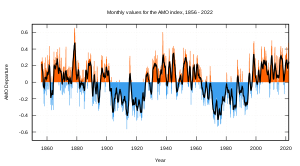
D. (AMO) The Atlantic Multidecadal Oscillation went into it's warm phase in the mid 1990's (positive), that warm cycle should last about 25 years. In fact it's last cold year was during the season of 1995-1996, which was not only snowy but very cold. We are well into that warm phase and we have the better part of a decade before it begins into it's cold cycles once more. This is not very helpful to us, if you want cold and snow anyhow. When this goes this cold once again we are going to have some amazing winters in store, something to look forward to I guess?

E. (PDO) The Pacific Decadal Oscillation went negative just a few years and that marked it's new 30 year cold phase which will remain that way for decades to come. This has to do with waters off the coast of Alaska and have an effect on the westerly flows that come from the west to the east which brings us most of our winter time weather. During the cold phase of the PDO increased precipitation coming in from the northern Pacific brings extreme snowfalls to Rockies and Alaskan glaciers typically begin to reclaim the land they previously occupied. During some winters depending on some other factors this could really help us out, or hurt us. This year I can see how it helps us.

That's all for the oscillations. I probably have you bored already! Let's move onto the good stuff now.


2. Below is the map for the projected temperatures for this upcoming winter season, sorry? I want to stress that while it seems extremely warm its the anomaly from the average. So there will be cold periods and there will be warm periods. By the time it's all said and done the winter could end up around 1.5 to 2.5 degrees warmer than normal.

3. The precipitation for the winter season is an important factor because it can give us an idea how much snow fall to forecast. Of course not all the precipitation during the winter will fall as snow, so we need to come up with some sort of system to figure out how much snow could fall with average precipitation while factoring everything into the equation that we talked about so far. The average winter time precipitation for north Jersey (Dec-Mar) is:
December- 3.63"
January- 3.83"
February- 2.96"
March- 3.79"

Total liquid equivalent: 14.21"

Now you have average liquid over the winter time period. After factoring in the whole picture, elevation, averages, and little bit of love you can make a good snow map. Ok, maybe love is a little much...

Below is the total snowfall per season since I started my measuring back in the day. The average snowfall for my town at 1,000 feet is 55" inches per season which means most of north Jersey averaged 50"-60" depending on elevation mostly. As you can see we have seemed to reach a "peak" season last winter, so I can only assume it's downhill from there. I would put this up coming winters snow totals at just average to slightly below.

4. The snow map!


5. Previous winter outlooks:
Winter Outlook (Nailed the north Jersey forecast!)
Winter 08-09: Winter Outlook (Over did the snow totals a bit)
Winter 07-08: Winter Outlook (My inexperience did me in on this one)

6. What's it all mean?
-Snowfall will be near normal to slightly below
-Temperature will be 1.5-2.5 degrees warmer than normal
-Ice and sleet may be a more common event than snowfall
-May be very dry for extended periods of time

Any questions? Comments? Suggestions? Comment below or email me at millirod@kean.edu