We have had plenty of cold air lately, but almost no natural snowfall. This may end up being a cold winter which is not alway a good thing. Last winter was warmer than normal with copious amounts of the white stuff while previous years were much colder with half the snowfall. Why you ask? This is where I get a little advanced, so try to follow along.
There is short range forecasting and then long range forecasting. Long range forecasting requires a strong knowledge in atmospheric dynamics, oscillation patterns, and teleconnections. There are several patterns which directly impact the weather here in North Jersey:
NAO (North Atlantic Oscillation)
AO (Arctic Oscillation)
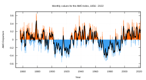
AMO (Atlantic multi decadal oscillation)
ENSO (El Nino Southern Oscillation)
PDO (Pacific decadal oscillation)
PNA (Pacific North American)
QBO (Quasi biennial oscillation)
All of these have a negative phase and positive phase, as well as "neutral" in between. Some switch phase weekly, biannual, yearly, and even every 30 years. Our negative NAO supplies us with stormy weather and cooler temperatures, and we have been negative! The problem is the La Nina which likes to track storms up the Appalachians and also the extremely negative arctic oscillation which is providing us with too much cold air dry air.
Current ENSO phase (La Nina)
Last year the AO went record negative. In fact the graph only went to -4 and the climate prediction center had to fix the graph to go to -6. Well, the AO may reach another record minimum in coming days.

The cause? Strong stratospheric warming over the high latitudes. The most impressive I've ever seen. Take a look at the animation, you can see the sudden warm up over Siberia.
You think it's cold here? For December it's very impressive. In fact parts of Europe are seeing the worst winter in several hundred years. I wish I knew why, but it could very well be the fact that our current solar cycle is the weakest since the Dalton Minimum in the early 1800's.
People are alway talking about how the winters here haven't been so good in the past 20 years. You here from your parents how bad the winters were "back in the day", and most people think of global warming. Wrong. For one the intense solar cycles of the 90's and 00's lead to warm decades. Also the AMO shifted into it's 30 year warm phase, and when it goes back to negative within the next 5 years expect winters similar to the 1970's.
We also have an unfavorable Quasi biennial oscillation phase. Every 28 months the winds in the stratosphere above the tropics shift direction from easterly (negative) to westerly (positive). Current we are positive which means storm track further inland and more intense hurricane season. The QBO was positive in 2005 as well when we had our record hurricane season. The La Nina, westerly QBO, and positive AMO means increase in hurricane activity. Not caused from global warming.
We still have a lot of winter to go. In fact, it hasn't started yet. Every winter brings something new and interesting. I'm sure this one will do the same.


No comments:
Post a Comment