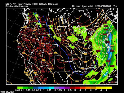
Well the once thought to be Blizzard of February 2009 has been tracking well off the coast of New England with all models except the UKMET, which means we get very little if any snow at all. But, the ALL the models, even the Euro has been bringing each storm to far east and there is always a northwest shift. If the trend from the entire winter applies for this storm than that puts us in the target zone, let's see what happens.
Don't lose all hope, remember keep the unlikely in the realm of possibility.
Saturday, January 31, 2009
Record January?
Well, today is the last day of January and one of the worst I have seen in all my years. Lake Musconetcong, Lake Hopatcong, Budd Lake, Saxon Falls Quarry, and Culvers Lake are in the top ten biggest lakes in the State and everyone is completely frozen over. If fact Lake Hopatcong, the biggest lake in New Jersey has an 18" ice cover. I was talking with a man who has been fishing the lake all his life and he said that in his 40 years of ice fishing he as never seen that lake freeze over so thick. Ice fishing is really going strong here across North Jersey and there is no worry about breaking through, the lakes can even support a fully loaded 18 wheeler of 80,000 lbs which is similar to the ice roads of the Canadian North Country. Below is a lake effect snow squall over one of NJ biggest lakes:

The current snow pack in the Mountains of north Jersey has compacted to around 8" inches but that is very deceiving. After melting down the snow pack, which I did, I found out the liquid equivalent is 1.8" inches! With the normal 10:1 ratio that should equal 18" inches of snow, not the 8" inches that we have. I was walking through the woods and I was only breaking through about half an inch which was the powder that fell yesterday with those snow squalls across the area. I even took my Trailblazer off roading today and the snow pack is so strong my car only make a small indentation on the snow, or should I say "ice" pack. With 30"-45" across the Mountains so far this year we are well on our way to that 60"-75" average. Below is the snowpack for January: 

There are many rivers across New Jersey but the Musconetcong River is the one that has the largest vertical drop in the state, was begins in Lake Hopatcong and ends up in the Delaware. This river is now completely frozen over in most section except where the fast moving water is in the center. The river is choked with ice flows and the trout are very active! 

We also are seeing one of the coldest January's ever on record, with 24 days this month without getting above freezing, 15 days of snow, and 29 days with a snow pack greater than a Trace. January's anomaly was -5.94 degrees below average getting into the top 10 coldest of all time! The average high was 27 degrees and average low was 13 with a monthly average of 20.5 degrees. The daily high was 8.6 degrees below average and the daily low was 3.3 degrees below the average, but the this months snowfall was 1.3 inches below the average.

I will be doing more average for Walpack and High Point Monument to see what happened there. Do you like these kinds of updates? Let me know what other information you would find useful.
Friday, January 30, 2009
What are the odds?
Well, once again there are two different teams of models, but the Euro and GFS are on the same side for once?


These following models show the storm going out to sea:
GFS, EURO, NOGAPS
These folling models show the storm riding just offshore:
Canadian, JMA, UKMET, GDEX (here all the following models in order)


Ok, so since the EURO and GFS are on the same side I think the GFS is wrong like it usually is 3-5 days out, meaning the EURO is wrong as well. There will be a storm coming up the east coast and a band of 8-15 inches will occur between New York City and State College PA, but who get's it? That's what I need to find out, check back tomorrow.
Thursday, January 29, 2009
Major storm coming Tuesday
Well, with 32" of snow this season at my house we are right where we should be, but a storm is on the horizon which will benefit the higher elevations. On Tuesday of next week a storm will ride up the east coast and mostly likely start as rain for the most of the area, then as the storm strengthens it will start to snow at High Point. From then on out the snow levels will begin to drop with time and significant snowfall is possible. Then the storm will clear out, but a few hours later some back lash snow will move back in putting down 4-6 inches more. While all this is happening New York City gets mostly a rain event and only your position west and elevation will help out, not so much how north you are. This is what the models are saying right now, in fact they are predicting a blizzard just to our west, and the Euro is one of the models showing it.
A major snowstorm is on the way, let's just hope the low track off of the coast and not west of the mountains.

A major snowstorm is on the way, let's just hope the low track off of the coast and not west of the mountains.
Tuesday, January 27, 2009
Snowmap
So, I did do a snowmap, which means I expect a "decent" amount of snow, but I am really concerned about the ice storm coming. Schools tomorrow in Northwest Jersey will be closed without any doubt in my mind and the roads WILL be a sheet of ice. This ice storm could once again cripple Mountain Creeks lighting and snowmaking systems, just if you don't have to go anywhere tomorrow than don't. This ice storm could be worse than the last one back in December as over half an inch of ice will accumulate over the 3-6 inches of snow that falls. Check back tomorrow for more.


Map Disco Up
Well, I have the map discussion up and running. Let me know what you think. And I will have a snowmap when I get home tonight. Click the link below to access it.
Map Disco Jan 27th
Map Disco Jan 27th
Monday, January 26, 2009
Ice again, yawn, who saw that coming
**Sigh** So who likes ice? Well you don't have much of a choice if you live in anywhere in New Jersey. What we are looking at is the storm starting as snow and accumulating to a few inches, then it will change to ,and eventually turn to freezing rain across *most* areas. After the good part of the storm is passed through the cold air will move back in and the storm will go back to snow putting down some more of the white stuff. I was planning on doing a map discussion tonight but I have too much work to get done, tomorrow is my early day and I will get right on it ASAP. And I will have a snow map...
Expect more updates tomorrow evening. Sorry for slacking on the blog as of lately, this school work is getting to be a bit much.
Expect more updates tomorrow evening. Sorry for slacking on the blog as of lately, this school work is getting to be a bit much.
New Poll
Vote on the poll to the left ------------------>
Let's see who's going to be right, I said 3-6 inches.
It's on!!!
Let's see who's going to be right, I said 3-6 inches.
It's on!!!
Sunday, January 25, 2009
Map Disco!?
Ok, so my map discussion did not work. I needed to convert it to WMV which I don't feel like doing right now! Haha, I hate Sunday nights...
Anyway I will post one tomorrow night after the 18z models come out, might not be till like 9:00 at night though. But I can say, a winter storm is on the way :)
Wow that rhymed... Sweet
Anyway I will post one tomorrow night after the 18z models come out, might not be till like 9:00 at night though. But I can say, a winter storm is on the way :)
Wow that rhymed... Sweet
Saturday, January 24, 2009
What the heck
I cannot believe it. The models are ALL over the place with the storm. In fact, I have no idea which day it is coming! Just between the 27-31st, that's all I can really say. No two models are saying the same, for example the GFS has a snowstorm(big surprise), DGEX has a snowstorm for the south, Euro shows nothing, Canadian shows rain storm, UKMET has no idea whats even going on, and I the weather guy know whats wrong.

The models do millions if not billions of calculations and has a lot of physics with them. Since the storm is now relatively "medium range" out then the calculation part should not be too far off, unless the physics is messed up. The models are not use to having two branches of the jet with very cold air to the north and very warm air to the south, it's confusing them all, even the Euro that I talk to highly about. Now that's where the meteorologist comes in (that's me), and that's when I refer to blocking patterns such as the NAO and AO. Below is current blocking patterns over the northern hemisphere which is not too prime for any development of storm systems in the east, let alone snowstorms. Things can change though...
Below is the storms tracks of the past 30 days. As you can see, they either went off to our south, to our west, to our north, or to our east. THAT'S every direction it can possibly go! But there was a few that tracked to our favor. I don't see how this trend is going to just stop, in fact it should continue for the rest of the season.
If I had to give this snowstorm a percentage to hit us, it would be a at 30% right now. But with a southern jet present any storm that comes will have ample moisture to work with and someone is gunna get dumped on, let's just hope it's us? Ok?
Thursday, January 22, 2009
Update
As for the storm at the end of the month the Euro right now is showing upper level warmth and a below freezing boundary layer. That means freezing rain and sleet! :/ Let's see what the 00z models say tomorow morning.
On another note:
February looks interesting, enough said for now. Hint hint.
On another note:
February looks interesting, enough said for now. Hint hint.
Tuesday, January 20, 2009
The future
So far this year my town has had 30 days of below freezing high temperatures. Now I have been keeping track of this for 6 years now and the most to date was 32 days below freezing for the whole winter season. Needless to say, we are going to beat that record and near 45 days!
Let's talk about something very interesting. Snow.
This year I don't expect any of those two foot snowstorms, I'm not forecasting one of those until February of 2010. I do believe this February will be above average in terms of temperatures, and perhaps WAY above normal in terms of snowfall (Not for the coast).
As of right now the models are showing a one, two punch. That is, two consecutive Nor'easters back to back for the 27th-29th. It's still a little far out but the models, as of now, are showing all snow. Don't get excited just yet, let's give it a few more days. I have a bad feeling that it may end up as ice going to rain, simply because of a La Nina that developed and the pattern so far this season. Take a look, click for bigger image.
Storm #1

Storm #1 exiting, and storm #2 coming in

Monday, January 19, 2009
It's mid-winter, let's recap
Back on October 8th I posted my winter season outlook. (Go check it out, see how right I was) Anyway, let's go over that now.
"All these leads me to believe that winter temperatures will be near normal, day time highs will be below normal but the over night lows will be warmer than normal. With the AMO/PDO in their current phase it suggests that in working with the NAO winter will bring above average precipitation and season snow totals will finally get back to normal to above normal. Whenever the NAO goes negative in the winter I can almost say that a coastal storm will form! That's a good thing for snow lovers. We will have some extreme cold days but because of the AO trend it doesn't seem likely that harsh long-term cold will be the case this year, which is good because really cold weather lowers seasonal snowfall. Remember check the NAO often! Here is the forecasted seasonal snowfall."
Let's see how this year is REALLY going so far. First we will take a look at the temperatures, and since we got a first snow storm in October I will start there: (Sussex County)
Oct: -1.4 below average
Nov: -1.8 below average
Dec: -0.5 below average
Jan: -5.9 below average
Ok, so with the temperatures I said the season will be near normal. It looks significantly below average to me. Each month the daytime high was colder normal, but every month except January had night time lows warmer than average. Let's see what happens in Feb and March. Moving onto the snowfall amounts. (Sussex County)
Oct: Trace - 15
Nov: Trace
Dec: 13 - 16
Jan: 7 - 10
Season total so far: 20" - 40" across Sussex County with the greatest amounts in the higher elevations. As of right now, we are right at average, thanks to that rare October snow.
Unfortunately, from central Jersey south they aren't that lucky. Near the coast, they have picked up very little in the way of snowfall. Some places have a seasonal total of a Trace. Just like in my season total snow map, there was going to be a large variation from the coast to the mountains. And I based that mainly off of the warm phase of the AMO. (Read my winter outlook to get a better understanding) http://meteomaddness.blogspot.com/2008/10/north-atlantic-oscillation.html
Sunday, January 18, 2009
Oddly enough
Well, the latest NAM tracks the coastal off the coast giving New York 2-4. Let's see if it can track more inland, I hate these models...

Saturday, January 17, 2009
Clippers
Chris, I wanted to answer your question but I need a lot of space. So I'm making a new post:
Question:
"Okay So I've been sitting here researching all the weather websites. They are saying 2 to 4 from the clipper. its way uyp by the great lakes? What can we expect from that? And Also since most they can never forecast weather i think the coastal storm will hit us?"
Answer:
Yeah I did notice that a lot of sites were saying two-four inches of snow. We have the three major ones being weather.com, accuweather, and Noaa. Most of all those other sites just take their forecasts straight from Noaa (like wunderground). But Ill only go with the one-two inches, two inches being generous I think. Clippers just don't give us a lot of snow, and I have a little story for you.
When I was coming home from Louisville Kentucky I had to cross over the Allegheny Mountains of West Virgina and Maryland. As I was going up the west slopes there was precip falling the entire time, until I hit Big Savage Mountain. From that point on I was now on the east slopes of the Mountains and going down hill. Within a minute it went from being moderate precip falling to blue skies and temperature rose. This is called a rain shadow and it's why clippers and lake effect snow can rarely reach us with ample precip.
As air rises it expands and begins to cool (7 degrees per thousand feet) which allows for condensation. This is why the Mountains of West Virgina, North Carolina, and even North Georgia can get lake effect snows! It just sucks the moisture right out of the atmosphere. Now when the air finally makes it over the mountains it starts to sink and instead of cooling, it now warms up and becomes dry. Unfortunately with the mountains to our west, this happens to us all the time. You can blame the Poconos, and even High Point!
Since the storm is now dried out, it turns to the ocean to intensify. The only problem is that we are a little too far away from the ocean so the only people who benefit are eastern Long Island, coastal Jersey, and Cape Cod. If you want some nice snow, Cape Cod is the place to be this weekend!
This clipper should squeeze out some light accumulations (1-2)and the coastal storm will likely miss us entirely. But like you said, these models can never forecast weather right so always keep the unlikely in the realm of possibility.
Hope this helped some!
Swing and a miss
Well if you voted team Euro, you were right. What a surprise? This clipper will hit us, but at the sacrifice of getting missed by the coastal low. All we will get is a few snow showers with possible accumulations of an inch in northern Sussex county. **Sigh**


On another note, the extreme COLD last night!
Northwest Jersey
Warm spots (Yes, Warm)
Mount Olive: -2.0 (Elevation +1,200)
Netcong: -5.0 (Elevation +1,050)
High Point: -7.0 (Elevation +1,800)
Wantage: -8.0 (Elevation +1,000)
Cold Spots
Peaquest: -10.0 (Elevation +500)
Walpack: -12.0 (Elevation +300) *Note
Sparta: -13.0 (Elevation +600)
Sussex: -14 .0 (Elevation +400)
***DAILY RECORD BROKE (old record -13.0)
Northeast Jersey
Newark: +5.0
Teterboro: +4.0
New Brunswick: +3.0
The Walpack station went offline at 2 am last night and wasn't turned back on till 9:00 this morning. This station was falling about 2 degrees every hour, but if I even go with 1 per hour than the station hit -18 degrees! I think this station may have passed -20! Now ALL TIME record low for Sussex County NJ is -29 (-34 state wide), but who is to say this station didn't break it? I think NOAA should look into this very carefully with the rate at which this stations temperature was falling. Below is the temperature graph from Walpack last night and I tried to reconstruct it to fit the curves to other valleys in Sussex County. Click for bigger images.

Here is a look at Walpack with google earth. The valley is only 300 feet above sea level and the mountain tops exceed 1,600 feet! It's actually the biggest vertical drop in New Jersey, and personally a prime spot for a ski resort. This valley is potentially the COLDEST spot in New Jersey, but why?


Here is a look at the contours of the mountains all around Walpack. The cold air originates from the mountains above, and then since cold air sinks it falls into the valley. Also the center of the valley as seen from the image above is cleared farm land. This allow for more radiative cooling. This is exactly what happened with Montague and Sussex the past two nights, except they only have tall mountains on one side (High Point) but Walpack is totally surrounded. The picture below shows how the cold air falls down into the steep valley and becomes trapped, it's the perfect set up. I woud say Walpack easily hit -20 last night, or maybe even lower?

Friday, January 16, 2009
Longe Range
As I am sitting in my room the outside temperature is 1 below, but unfortunately since I'm over a 1,000 feet I can't get nearly as cold as the valleys. The lower elevations are going to be the COLDEST locations, like Vernon Valley, Sparta, Sussex Boro, Walpack, Hackettstown, Hope, and other low lying areas. The warmest areas will actually be the highest areas like Hopactcong, High Point, Sunrise Mountain, Highland Lakes, Allamuchy's, and other high areas. Some areas in Sussex actually hit -13 last night, but tonight I wouldn't be surprised to see near -20! Let's go to the long range.
As I am waiting for the models to come out after 2:00 A.M. (yes I'm crazy), besides drinking a bunch of coffee, I am thinking toward the future. If this storm doesn't work out for Monday, then the GFS is hinting at one for the end of this up coming week. After that storm, cold air will pour back into the region, maybe even colder than this latest blast. January is already 8 degrees below average, but could end up over 10 below and perhaps become the all time record. We will have to see about that, but it's close!
As I am waiting for the models to come out after 2:00 A.M. (yes I'm crazy), besides drinking a bunch of coffee, I am thinking toward the future. If this storm doesn't work out for Monday, then the GFS is hinting at one for the end of this up coming week. After that storm, cold air will pour back into the region, maybe even colder than this latest blast. January is already 8 degrees below average, but could end up over 10 below and perhaps become the all time record. We will have to see about that, but it's close!
Euro VS GFS. Again.
Well the GFS still has the storm along the coast, but the NAM, NOGAPS, JMA, and EURO bring it out to sea. Here is a look at the GFS:


And the Euro:

So far this season when the GFS and Euro faced up to one another, the GFS lost. Maybe it can still conqueror over it's arch enemy. But this time the GFS has buddy's backing it up, like the UKMET and Candian models.
Check them out:


The two big leaders here are GFS and EURO, so I set up a poll to the right of this post to see what you, the reader thinks? Put your best forecasting skills to the test and see if you got what it takes!
Guess what the 12z model shows?
If you read my post below (and I suggest you do before reading this one) then I am getting excited now. What I thought would happen has happened. The storm to our north goes further north and the storm to the east comes farther west. As of right now, if I went off the model it would be 3-6 inches of snow. But I have a feeling its not done being adjusted west, so it could even be more. Check back after 6:00 for more!

Latest GFS run: (1/19/09)

One, two, PUNCH?
First let's just update on this latest cold blast. Here are some low temperatures from last night:

NJ-
Hackettstown: -1.0
Schooley's Mountain: -1.4
Wildcat Ridge: -2.0
High Point Mon.: -3.0
Belvidere: -5.0
Hope Township: -6.0
Montague: -10.7
NH-
Mount Washington: -25.0
ME-
Bangor: -23.0
Rangeley: -26.0
Caribou: -36.6
VT-
Jay: -15.0
Stowe: -19.0
NY-
Saranac Lake: -12.2
Lake Placid: -16.6
Lake Placid: -16.6
Ok, so it was cold this morning. And High Point only got down to 3 below, but the west side of the mountain fell to below -10.0 degrees! I guess that 1803 foot mountain blocked that cold air from pouring into the heart of Sussex County.
Now let's talk about this possible one, two punch for Sunday-Monday-Tuesday. There is not one but two storms. The first one is a clipper but as of right now looks like it will go off to our north. After that storm goes into New England a secondary low will form off the coast of the Delmarva and pull north. That storm passes off to our east giving New York 3-5 inches, but northwest Jersey gets nothing. But is this how it will really happen?
So far this year the storm track on the models has been either to far east, or to far south. Ok, this means that the first clipper will ride off north of us, but that's what we want. If that storm goes off to the north it means the storm coming up the coast will track further west. From all these past BUSTS on these storms (because of models being wrong) the people to our north and west have had all the snow. Now we are those people to the north and west, let's see what happens. Here is the 6z GFS run. If/when the model changed I will post a new blog.

Thursday, January 15, 2009
A Global Warning?
The average temperature has been falling since it's peak in 1998 and now 2008 temperatures are in and they took a nosedive. Just check out the graph: (Click for bigger image)
The cooling across the global is most likely due to the reduction in solar irradiance which could possibly last years and years to come. Because the solar cycle has been delayed by several years, global cooling will most likely continue for atleast the next two to three years. Our sun may be reaching a new solar minimum which could be equal to the extent of the Dalton Minimum during the Little Ice Age. Also Here see for more about the solar cycle effecting climate.
The cooling across the global is most likely due to the reduction in solar irradiance which could possibly last years and years to come. Because the solar cycle has been delayed by several years, global cooling will most likely continue for atleast the next two to three years. Our sun may be reaching a new solar minimum which could be equal to the extent of the Dalton Minimum during the Little Ice Age. Also Here see for more about the solar cycle effecting climate.
Sunday-Monday Snows
Well as of the right the GFS and NAM really blow up this storm, but off to the east of us here in north west Jersey. Folks out in New England could possibly get 4-8 inches of the white stuff while we will be lucky if we get an inch. That what it seems to be as of right now, it's still several days so maybe things will change.
The 18z NAM:

Let's talk about the cold
A few day's ago I issued a 7 day forecast (Going colder than most sites/tv stations would be comfortable with). Let's see how right I was up till today and talk about the up coming days.
Mon 1/12:
My Forecast- 27/16
Actual- 27/12
Tue 1/13:
My Forecast- 33/15
Actual- 29/14
Wed 1/14:
My Forecast- 18/2
Actual- 17/7
Thu 1/15:
My Forecast- 9/-7
Actual- 15/?
As for Thursday (Today) the low will happen at mid night sometime after the second arctic front moves on through.
Fri 1/16:
My Forecast- 2/-10
Actual- ?/?
As for Friday there is no actual cause it hasn't happened yet, but the low will be set sometime in the morning hours around 7 A.M. When I forecast I do from mid-night to mid-night, so Friday night the temperature will actually rebound a little.
Sat 1/17:
My Forecast- 11/-2
Actual- ?/?
I may actually want to adjust Saturday to 13/2, but that still cold. Don't ya think?
Sun 1/18:
My Forecast- 21/3
Actual- ?/?
I am going to adjust this one to 23/9 with a chance of snow.
That's it for now, Ill post again after the 18z models tonight for snow chances.
Wednesday, January 14, 2009
Euro and DGEX, partners in crime?
European model is still showing a snowstorm along the coast for Monday-Tuesday. Now the latest run of the DGEX shows this. Its self explanatory, let's just see if the models are consistent.
Ironically, while Obama is being sworn in, one topic of discussion will be global warming. Let's see how they like 20 degrees with heavy snow. The global warming belief seems to be dieing out with the new year...
P.S. (As you can tell, I am not one to believe in the whole global warming theory. Comments and emails are totally acceptable, I love a good debate.)
I need your help!
I am always trying to find new topics for the blog and try new things to make it more interesting and improve it. Is there anything you the reader would like to see? See more of? See less of? Learn more about? And of course, if you ever have any questions feel free to email me or comment this blog, I would LOVE to answer any questions you have about weather, climate change, computer models, and etc.
If you can, please comment on this post if you have any suggestions for me. I would really appreciate it!
P.S. I was just watching the weather channel and they were trying to explain why 2008 was the coldest year in 30 years world wide. (They blamed la nina) They actually had the nerve to say that 2009 is already warmer than 2008. IT'S 14 DAYS IN? HOW CAN YOU SAY THAT? Now I remember why I stopped watching the weather channel. They are biased, inaccurate, and unprofessional at times.
More on Thursday
Sorry for no post today (well actually yesterday now). Between meetings, some snowboarding, and work I didn't have much time. Well, let's get started.

This Thursday some light snow will be falling across the state and with 35:1 snow-liquid ratios any little bit of precip will allow for a few inches of snow. The 00z models were not very impressive and makes me think that perhaps we will get ripped off. Tomorrow I will have more with the noon time model runs, check back for a snowmap, if needed.
Longe Range Outlook:
~(All I am doing for the longe range is looking over the GFS and telling you what it is saying. I will go day by day, and let me know what you think. If the readers like it, Ill try to do it more often.)
*Day 1 (Thu Jan 15)- 0.15 precip, 516-504 thickness values
"About 4.5 inches of snow will accumulate with a high of 15 and low of -5"
"About 4.5 inches of snow will accumulate with a high of 15 and low of -5"
*Day 2 (Fri Jan 16)- 0.00 precip, 500-497 thichness values
"Very cold with of high of 0 and low of -8"
*Day 3 (Sat Jan 17)- 0.00 precip, 516-502 thickness values
"Little warmer with a high of 13 and low of -1"
*Day 4 (Sun Jan 18)- 0.01 precip, 522-520 thickness values
"Few flurries with a high of 24 and low of 9"
*Day 5 (Mon Jan 19)- 0.00 precip, 522-515 thickness values
"Cooler with a high of 20 and low of 10"
*Day 6 (Tue Jan 20)- 0.00 precip, 528-517 thickness values
"High of 25 and low of 13"
Now here is the interesting thing. You see what the GFS has forecasted for Monday and Tuesday? Check out this run of the Euro, that's a northeast snow storm...

Here is a link to the model page that I have made, it's a work in progress but I hope to add much more as time goes on.
Monday, January 12, 2009
Thursday Snow
Here is the GFS model on Thursday's snow. It's not a big storm and it has very little precipitation with it, but why am I getting excited for it? Well, when it's 10 degrees and snowing liquid-snow ratios change from the usual 10:1 to 35:1. Now if we get the predicted 0.20 inches liquid equivalent then that equals 7 inches of EXTREMELY light fluffy snow. It's just a matter if we get the heavier band of snow or not. Check back tomorrow for more. 

Sunday, January 11, 2009
Records will be broken
Just take a look a this seven. And I tried to be as conservative as possible, meaning that those temperatures could and mostly likely will be colder than what I forecasted.

Saturday, January 10, 2009
What a bust!
I was the one calling for the least amount of snow, and even I over did it! Wow. For one, most of the storm was just light snow or dry slots, which I knew was going to happen. And also most of any precip that falls over night will be a mix! I can see how another inch accumulates on top of what you have now but not much more. That sets the final totals at 3.5-6.0 inches, and that 6 inches is very generous. Which means I busted by 2.5-3.0 inches. But what else is new right? Ice and getting ripped off is the story of these past 3 winters now. Tomorrow we will turn our heads on this upsetting experience and look forward in time to bigger and brighter things, deal?
Answers on snowfall amounts
Im an still sticking with my original amount of 5-9 inches with higher amounts in the northern part of Sussex county. From what I hear accuweather is saying 2-4 inches, and that's gunna bust because we should get double that. The models are showing some mixing heading into our area, which once again, shouldn't be a surprise to people, and certainly not to me. Ice and sleet is the story for the past 3 winters now.
Soundings:
I just checked the soundings with the 6z runs and the NAM is showing all snow, as well as the GFS but im sure most of us will see a change over to sleet. Im calling for 5-9 for northwest Jersey, and im sticking to it!
Soundings:
I just checked the soundings with the 6z runs and the NAM is showing all snow, as well as the GFS but im sure most of us will see a change over to sleet. Im calling for 5-9 for northwest Jersey, and im sticking to it!
Friday, January 9, 2009
Snowmap
Here is the snow map. Although we are in the 7-11 inches the majority of us will see 5-9 inches. If I'm wrong an we get more than, THATS GREAT! Only time will tell. 

And if you happen to measure how much snow you get in your town feel free to comment this post and let everyone know!
On a separate note:
Does anybody know Paul Kocin? The reason I ask is that he may be coming to Kean University in February for an assembly. He is the man who wrote the book (seriously) on northeast snow storms and is my IDOL. It's open to the public and I'm sure people from News12, Metro traffic & Weather, and some of the New York News station will be there. To anyone interested in meteorology it's going to be an amazing experience to meet and network with some big names in the field. I will know more about it in coming weeks and expect some blog posts all about it!
Comments
Do to recent spam comments on the blog I changed some settings so that each time you want to comment a word verification box will pop up. I'm not even too sure if it works. If it's a complete pain let me know, I just don't want a reader to accidentally click on a spam link and get a bad virus. Remember, if you do see a comment on this blog that has a link do not click on it. (Unless ofcourse it's me)
Thanks! And try to comment this post and see if it even works. Let me know? Ok? Cool!
Thanks! And try to comment this post and see if it even works. Let me know? Ok? Cool!
Other blog
Just to let everyone know I have another blog committed to global warming, or "Glo-BULL warming". Check out the link for my personal thoughts on the controversial topic, and please comment, I would love to talk.
http://globullwarming.blogspot.com/
http://globullwarming.blogspot.com/
Thursday, January 8, 2009
WRF update
The WRF model, aka NAM at 18z just printed out 1.10 inches equivalent of precip. If correct, then the snow could be impressive. Just 1 inch of liquid equals about ten inches of snow at 32 degrees anyway. With a high 0f 27 and 1.10 inches then it could get interesting. It's not going to be wide spread, but someone, in a localized area, could get a foot of snow.
The general trend still looks to be 4-7 inches but keep checking back in, these things always change.
The general trend still looks to be 4-7 inches but keep checking back in, these things always change.
Things are lookin bright
Well after several snow squalls today about an inch of the white stuff has fallen at my house in Netcong on top of 1/4 inch of ice! Last night the temperature hit 33.1 for a few minutes then started to fall, so it did get above freezing. Today's on the other hand did not get above that 32.0 line which means Sussex NJ will now start a DEEP freeze that could last for the next two weeks without getting above freezing. It also seems likely we will have one day next week with a high in the single digits and a night that falls below 0.
With the pattern the next two weeks we need to start thinking about clipper systems coming from the north and west, because it's really the only type of snows we can get in a such a cold snap. This Saturday will be the first of these clippers which will bring several inches of fresh snow to our area! From then on out it will remain cold and some light snows here and there, but nothing to serious.
Unlike the last storm, I WILL make a snow map for this one. The reason I did not make one for the last is because I really didn't see the snow amounts that Accuweather, weather.com, NOAA, and local news channels were seeing. Upper level warm air was coming in WAY to fast to support snows for a long period of time and most of the "snow" period fell as either virga or a dry slot was over us.
January is looking bright, just not the last few days of the month :(
Monday, January 5, 2009
Long Range
I wanted to hold off on the snow map for now until tomorrow morning because a few things that I just don't see coming together yet. It still seems as if 2-4 inches of snow will fall for Sussex before the change over but I'm not to confident of what type of precip will fall in which areas. I have a feeling that the amount of frozen still could vary from 0.5-5 inches across Sussex and I want to check out more maps tomorrow morning.
Long Range:
Looking into the future after this storm a cold front will move through bring us the coldest and longest duration of cold in perhaps several years. There could be several days in a row where we won't be able to get above 20 degrees and maybe the first negatives since February 4th of 2007. The cold will mostly likely be the heart of our winter, but yielding little in the way of natural snowfall. The good news is that the ski resorts in the region will reach full operation, this will be Mountain Creek first in about 3 winters.
Around the 24th of the month a storm will ride up the coast, perhaps providing us with some nice snows, but it's all bad news. The storm is riding up a warm front which will bring in an all out January thaw where temperatures could reach the 60's. This warmth could last through the first week of February or even longer. Beyond this time frame, I would only be guessing what was going to happen.
I have a saying that one extreme leads to another of the opposite. So the coldest air in years would mean that the warmest air in years will soon follow. It always happens that way with the weather here in Northwest Jersey, even in the historic winter of 95-96 when over three feet of natural snow pack melted in a week with extreme warmth and a massive rain storm. It's just the way things go...
It's never all snow anymore...
Well, yet again, a storm is on the horizon that will bring wintry weather but of course there will be a change over from snow. That's no surprise.


First off let's look at the NAM model and then check the atmospheric soundings to see what kind of precip we can expect.

At the start we can see a lack of cold air around but the NAM is a model that does not do very well with cold air. Thats why we now go to the sounding.

This sounding shows all snow, but only for the start.
Below is mid way through the storm and NAM shows some warm air around, but then look at the sounding. The surface temperature remains below zero. This is clearly sleet and freezing rain above 500 feet in elevation.


For the end of the storm on Thursday the NAM is hinting at some back lash snow which could put down a little more accumuations. Here is the model and sounding:


With the information I have now I would say 2-4 inches of snow could accumulate before the sloppy change over then significant ice is possible on the mountain tops, something Creek doesn't want more of. But a quick inch could fall on the back side before it all ends.
Right now I'm working on a snow map waiting for more updates to come out, and also some footage of my Maine trip. I will posts more blogs a little later on, probably a few of them today to catch up.
Sunday, January 4, 2009
Back from Maine
What happened to the storm?
After spending an entire week without checking computer models I am back and getting into weather mode again. When I left I was looking at a storm for the 3rd of January which could have been a big snow maker. Since today is the 4Th, it's safe to say nothing happened, not yet anyway. The weather has been modified slightly and some of that energy from the storm I was seeing a week ago will still be coming our way.
During the week a storm will ride up the Mountains with snow at the start, then going to a mix, and then to just plain old rain. But what else is new right? It's been that story for the past two years already. The position of the storm means everything and with a lack of cold air in place it's gonna be sloppy instead of snowy.
More updates tomorrow with maps!
What about snow making?
After this storm moves on through it looks like the longest stretch of cold air will move this winter and could yield some minor snows here and there, but I don't see anything to get excited for just yet. Mountain Creeks trail counts will rise steadily and could near full operation by mid month.
December averages.
~ 13.8 inches of snow (185% of the average)
~Average high = 38.2 ( -1.2 from average)
~Average low = 23.8 ( +2.9 from average)
~11 days of snow
~15 days of snow pack
December ended up slightly warmer than normal but with almost double the normal snowfall for the month.
Tomorrow I will post videos and pictures of my trip to Maine and try to check up with the current weather events coming our way. I need to unpack and get some sleep tonight but expect more post/posts tomorrow! Think snow.
Subscribe to:
Posts (Atom)


