Thursday, December 30, 2010

The Storm....

The past storm really hit some places hard with over 30" inches of snow toward the city, but western areas likes Phillipsburg picked up just 3.5" inches. The snow map I issued was over done to the west and underdone to the east, typical of convective bands of snow. Morristown at one point was getting 4 inch and hour rates with thunder and lighting while I was getting light snow. To make it worse I only live 20 minutes from there and I watched the band of snow stall out just a few miles from my house!

Here are some totals:

...MORRIS COUNTY...

BOONTON TWP 18.5 900 AM 12/27 COCORAHS

JEFFERSON TWP 12.8 600 AM 12/27 COCORAHS

HARDING TWP 12.0 700 AM 12/27 COCORAHS

PARSIPPANY-TROY 12.0 800 AM 12/27 COCORAHS

ROCKAWAY TWP 11.0 800 AM 12/27 COCORAHS

DENVILLE TWP 10.3 700 AM 12/27 COCORAHS

ROCKAWAY 8.0 800 AM 12/27 COCORAHS

MINE HILL TWP 7.2 800 AM 12/27 COCORAHS

ROXBURY TWP 6.8 700 AM 12/27 COCORAHS

MOUNT OLIVE TW 6.2 700 AM 12/27 COCORAHS

RANDOLPH TWP 6.0 700 AM 12/27 COCORAHS


...PASSAICCOUNTY...

CLIFTON 25.5 215 PM 12/27 TRAINED SPOTTER

HASKELL 24.5 200 AM 12/27 TRAINED SPOTTER

WAYNE 22.0 915 AM 12/27 TRAINED SPOTTER

RINGWOOD 22.0 810 AM 12/27 PUBLIC

WEST MILFORD 22.0 415 AM 12/27 TRAINED SPOTTER


..SUSSEX COUNTY...

HOPATCONG 7.2 1206 AM 12/27

NEWTON 7.0 837 AM 12/27

SUSSEX 6.0 1036 AM 12/27 CO-OP

LAFAYETTE 5.0 936 AM 12/27

HAMPTON TWP 4.9 144 PM 12/27

WANTAGE 4.5 413 AM 12/27


...WARREN COUNTY...

HACKETTSTOWN 7.0 935 AM 12/27

PHILLIPSBURG 3.5 1057 AM 12/27


You may wonder why West Milford is in red. And thats because it's a false report and the "trained spotter" who reports from there always has higher snow totals then everyone around him. Consistently!


There really isn't much weather to talk about in upcoming days. So I'm going to take a little break from blogging for the next two days and get my new weather station set up that I got for Christmas! So excited....

Monday, December 27, 2010

Well, that was interesting

The blizzard hit, but there was one sharp western cut off. At my house in Netcong only 8" of snow fell, while 10 miles east are topping 18" because of intense bands last nights. And just 20 miles east some areas are reporting 31.8". And central park is currently at 13".

Storm tally and update later

Sunday, December 26, 2010

Update on blizzard

Since yesterday I have no changes to my snow map. I want to stress how dangerous this storm is to everyone. Just because snow totals may not be as much as we got back in February, this system will be colder and produce a lot more wind! If you must leave your house make sure you have four wheel drive and do not go anywhere without making necessary preparations. Travel is discouraged!

In the event that you leave your home make sure to pack a safety kit. Water, flash light, shovel, kitty litter/or sand, blankets, food, and your cell phone are a must! If you get stranded in the storm don't not try to travel by foot! Stay in your car and notify locals officials of your location.

Map still looks good to me:

Drifts 3-5 feet could cause some roads to be impassable even by truck. Also colder temperatures will allow to the snow to stick much quicker to roadways and road salt will be less effective. Enjoy and be safe!

Saturday, December 25, 2010

Merry Christmas

As of yesterday morning all operational weather models were in agreement that the storm will go out to sea (OTS). Then the GFS at 12z showed a massive snowstorm along the eastern seaboard, and NCEP/HPC said the model wasn't initialized correctly. That basically meant to ignore the model completely. Then the 18z model came out and showed a similar scenario, and that began to raise some eyebrows. By Christmas morning all models (globally) went to the idea of a major east coast blizzard. Merry Christmas!

Take a look at the 18z NAM total liquid precipitation for the event:

Now I based my snow totals on this model only, and tomorrow I will make another snow map and adjust the forecast if needed. I mainly based it off the total precip (QPF) but also included the higher snow ratios in colder western areas. For every 1 inch of liquid 15 inches of snow will fall in western sections and 10:1 ratio toward the city. Here is my snow map, and no I'm not being conservative at all.

Any shift eastward or westward on the exact track can drastically change the total snow amounts. By tomorrow morning I should have a map that I'm finally happy with.

P.S. Just like last years blizzards, a major stratospheric warming event over the arctic caused the arctic oscillation to tank at record low levels. It just goes to show how weather somewhere else in the world affect us right here at home. It reminds me of the butterfly effect http://en.wikipedia.org/wiki/Butterfly_effect

Thursday, December 23, 2010

The Snow Drought

First off I want to apologize for not posting in the last couple of days. I've been busy working trying to get everything done before the holiday. Personally, you didn't miss much.

My last blog brought up the possibility of a Christmas snow storm. There are two problems with that as of now. First off the current system out to sea along the northeast coast is acting as a block slowing the flow and thus delaying the storm system. Second the delay in the storm system will allow for more bitterly cold air to attack the region sending the storm out to sea entirely. December will end with 0.4" of snow at Sussex Airport, thanks to an extremely cold and dry weather pattern.

Even with this practically snowless month Mountain Creek is having it's best start to the season in, well, ever. Natural snowfall doesn't help out resorts in this region to much, they rely on the man made snow. Real snow sublimates (evaporates from a solid to gas), melts faster, and disappears quickly in a rain storm. But the man made snow is more thaw resistant, rain proof, and makes for a better base. Now obviously natural snow makes for better surface conditions but thats all it's really good for, except for the mountains out west of course.

Here is a look at the Euro for the storm this Sunday:

After the New Year a pattern change will be in the works. One that makes for more mild and stormy weather. The problem is the storms will like to track up through the Great Lakes putting us on the warm side of things, but January will be more likely to give us some snow. I just can't believe December didn't provide us with one decent snowfall given the negative NAO and record negative AO. It just goes to show how different a La Nina season is compared to El Nino like last year.

P.S. Don't get bummed out just yet. While the best part of this storm will hit coastal areas and some fish out sea we may still get some light snow out it all. The storm is still 72 hours away, and things can and will change between now and then.

Monday, December 20, 2010

First Christmas Snowstorm Since 2002?

There is nothing like a perfect Christmas Eve by the fireplace, drinking a cup of hot coco, and watching the flakes fly. Will we all get that opportunity on Christmas? Well only if you have a fireplace, because the chance of at least some snowfall looks promising.

Currently the EURO, GFS, and DGEX are all suggesting a good dump of snow. They all predict around a foot for most of the state, but all we need is an inch for a white Christmas.

The GFS:

The DGEX:

The Euro:

Now some models like the JMA, GEM, and NOGAPS track the storm offshore. The event is still five days away and the models need a little time to get things right and come into agreement. It seems likely that places further east have a better shot at bigger snowstorm but if the track changes by just 50 to 100 miles then things could be very different. The difference between a major snowfall and partly cloudy skies relies on the exact track of this system.

I'll post tomorrow on the progress of the models and begin to make my forecast for the upcoming event. Make sure you all tell Santa what you want for Christmas, a SNOWSTORM!

Friday, December 17, 2010

The Void

I want to point out that our region is the only one with below average snowfall for the season thus far. In fact, we are the only ones without a decent snow event. Washington D.C., Cape May, Long Island, Virginia, Raleigh NC, and north Georgia are all ahead of us snow wise. Take a look at this sad map of current snow cover:

Will this trend continue? I personally believe so. In fact, after this weekend a 360 degree circle around us will have snow cover. This weekends storm looked bad to me all week, and I refused to jump on it. And it looks like that was a good decision because the storm will go out sea, missing us entirely.

There are several chances of snow after this weekend for our area. The first would be mid week, but that looks as if it could go south and give Washington another dump of snow. The second would be Christmas Eve into Christmas day. We just need to be patient, even I am becoming some what frustrated.

The good news is that the cold air has allowed the resorts to really pump out the white stuff and Mountain Creek is having their best start to the season I have ever seen. If we were in a snowy pattern we would probably be warmer which means the snowmaking could not be as extensive. In a way, things are working out well. Stay positive and stay tuned.

Thursday, December 16, 2010

European model changes it's mind

The Euro model is one the best weather models out there right now, and it shows a sizable snowstorm for most of the state come Sunday:

The only thing is, I don't buy it. Currently it's the only model showing this kind of solution and it could be just one bad run. I'm sticking with my little to no snow accumulation out of this weekends snowstorm. I could be eating these words by morning, but I just don't see it right now. I actually hope I'm wrong.

Check back tomorrow for final call and a snow map if needed.

Wednesday, December 15, 2010

Models in agreement now...

Once again the GFS was over done on this storm. It finally caught on to the idea that every other model has been seeing for several days. The storm looks like it will go out to sea.

It just goes to show that the United States has the least advanced weather models. We need to play a serious game of catch up to reach the level of the European model, or even the Canadian. Another one bites the dust.

After this storm I don't see any other major snow threats all the way up to January. This could very well be a near snowless December, and personally I give us less than 10% chance of a white Christmas.

I know we are all down in the dumps right now, but it's the weather! Things can change on a dime and we will get ours. The snow haters in the region can't be lucky all season...

Tuesday, December 14, 2010

Winter Storm Outlook

There are a lot of different weather models out there. Some are known to be notoriously bad, and others almost spot on. Let's take a look at a few of these and see which is the winning the model for our big snowstorm potential come Sunday.

1st up: GFS (Currently shows a 10"-15" snowstorm across most of Jersey)

2nd up: DGEX or extended NAM/ETA, same difference... (Similar to GFS)

3rd up: ECMWF or European model (Shows a storm going way out to sea, no snow)

I can go on for hours with different types of models. As of right now the only models showing a snowstorm on Sunday are the GFS and DGEX. They both run off of the same basics physics and computer program so I would expect them to be very similar. The odd thing is that the Euro, JMA, NOGAPS, UKMET, and CMC all have the precipitation just offshore from the Jersey coastline. Let's give the models another day or so. Will the GFS come out on top? Or will it bust like it did on the last event.

Sunday, December 12, 2010

The plunge

Our future for natural snowfall looks lame to say the least. We do have some possible chances in the coming week but as of right now it's way to early to get a grasp on it. After this nasty little rain storm expect sharply colder conditions for the rest of the week, with snowmaking temperatures 24/7. Mountain Creek and other local resorts may end up having more than half of their terrain open by Christmas. Impressive, but why?

We have had plenty of cold air lately, but almost no natural snowfall. This may end up being a cold winter which is not alway a good thing. Last winter was warmer than normal with copious amounts of the white stuff while previous years were much colder with half the snowfall. Why you ask? This is where I get a little advanced, so try to follow along.

There is short range forecasting and then long range forecasting. Long range forecasting requires a strong knowledge in atmospheric dynamics, oscillation patterns, and teleconnections. There are several patterns which directly impact the weather here in North Jersey:

NAO (North Atlantic Oscillation)
AO (Arctic Oscillation)
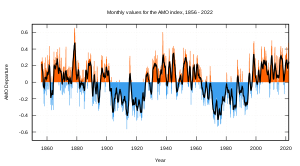
AMO (Atlantic multi decadal oscillation)
ENSO (El Nino Southern Oscillation)
PDO (Pacific decadal oscillation)
PNA (Pacific North American)
QBO (Quasi biennial oscillation)

All of these have a negative phase and positive phase, as well as "neutral" in between. Some switch phase weekly, biannual, yearly, and even every 30 years. Our negative NAO supplies us with stormy weather and cooler temperatures, and we have been negative! The problem is the La Nina which likes to track storms up the Appalachians and also the extremely negative arctic oscillation which is providing us with too much cold air dry air.

Current ENSO phase (La Nina)

Last year the AO went record negative. In fact the graph only went to -4 and the climate prediction center had to fix the graph to go to -6. Well, the AO may reach another record minimum in coming days.

The cause? Strong stratospheric warming over the high latitudes. The most impressive I've ever seen. Take a look at the animation, you can see the sudden warm up over Siberia.

You think it's cold here? For December it's very impressive. In fact parts of Europe are seeing the worst winter in several hundred years. I wish I knew why, but it could very well be the fact that our current solar cycle is the weakest since the Dalton Minimum in the early 1800's.

People are alway talking about how the winters here haven't been so good in the past 20 years. You here from your parents how bad the winters were "back in the day", and most people think of global warming. Wrong. For one the intense solar cycles of the 90's and 00's lead to warm decades. Also the AMO shifted into it's 30 year warm phase, and when it goes back to negative within the next 5 years expect winters similar to the 1970's.

We also have an unfavorable Quasi biennial oscillation phase. Every 28 months the winds in the stratosphere above the tropics shift direction from easterly (negative) to westerly (positive). Current we are positive which means storm track further inland and more intense hurricane season. The QBO was positive in 2005 as well when we had our record hurricane season. The La Nina, westerly QBO, and positive AMO means increase in hurricane activity. Not caused from global warming.

We still have a lot of winter to go. In fact, it hasn't started yet. Every winter brings something new and interesting. I'm sure this one will do the same.

Thursday, December 9, 2010

It's not our storm

Well, this blog is in response to yesterdays post. The GFS played it's usual games for day 4 out, and North Jersey will see primarily a rain event. The precipitation may start off as a wintry mix then go to a heavy rain for Sunday to end as snow on Sunday night. As of right now it does not look as if we will see much in the way of accumulation. It's just not our storm.

The good news is Mountain Creek is opening Saturday with 10 trails. At the rate they are going I wouldn't be surprised if they are 100% open by Christmas. That hasn't happened in the past 11 years I've been going there. After the rain Sunday snowmaking will resume around the clock for another week straight at least.

Creek's Forecast:

Monday: Snow Showers

High: 28
Low: 10

Tuesday: Partly Cloudy & windy

High: 15
Low: 4

Wednesday: Clear

High: 20
Low: 9


You wonder why my forecast is so much colder than any other site? That's because they adjust their forecast to climatology. So naturally it will be much warmer. For example NOAA forecasted 29 for a high today and the actual was 23, but five days ago they said 34 for today. That method of forecasting doesn't work to well in north Jersey, but it seems to work better in the city.

Not only that, but I live here in southern Sussex county. I know the weather here much better than some guy in Atlanta working for The Weather Channel or an employee at Mount Holly NWS who lives in south Jersey. In the end, my forecast it verify much better. And I think we should do a little experiment. Below I will post The Weather Channel and National Weather Service forecast for Mon-Wed of next week. Let's see who does better?

TWC:
Monday- 34/11 Rain/Snow showers
Tuesday- 22/12 Partly Cloudy
Wednesday- 24/19 Scattered Flurry

NWS:
Monday- 31/12 Snow showers
Tuesday- 23/11 Flurries
Wednesday- 26/14 Partly Sunny

Let the game begin...

Wednesday, December 8, 2010

18z GFS goes to all snow

The 18z GFS just came out and shifted the storm out to sea. Now this is just one model and only run certain run of it. The question is will it verify? The answer is I won't be sure until about 11:30 tonight when the 00z model comes out.

Tomorrow we could look at this blog entry and say one of two things:

1. Wow the GFS really caught on this storm well! All snow! Yay!

2. Global Forecasting System? More like Good For Shi..p if you ask me :(

We will find out the answer next time on North Jersey Weather Outlook! Thanks for watching.


P.S. I'm in the "joking" mood. Hence lots of sarcasm...

Tuesday, December 7, 2010

December let's go...

Today marks the 5th day in a row with snow flakes in the air. But up to this point accumulation has been minimal. Snowmaking at the local resorts is really going strong and it looks as if they should have no problem opening on time. I told you they would :)

Let's talk about the storm for Sunday to Monday. Most operational models have gone to the idea that it's wintry mix to start then turning to all rain and possible light snow to end it. Trust me, it's not what I want to hear either. We still have several days for things to shape up but it's not looking so good. The latest run of the GFS gives at least some hope for minor accumulations.

After our rain has turned the slopes into slush we have a big problem. The coldest air mass of the season will bring in temperatures that will not break out of the teens for highs. That means the slushy slopes will turn into an ice skating rink, but the guns will be able to go non-stop with high efficiency turning that surface into the frozen granular type.

There is still some uncertainty in this forecast. Check back daily to look for any updates. As soon as I get a better grasp on things you'll be the first to know.

Thursday, December 2, 2010

Snow Outlook

Well, it's December and I'm finally done with my "snowmaking" outlooks. The season for that has already started and temperatures that allow for the guns to be on will occur nightly and after this weekend will be 24/7. Now it's time to officially start snow outlooks!

Case #1: A clipper system will pull out the mid-west and bring snow all the way to Virginia and North Carolina and even some wet snow will mix in on the Outer Banks on Sunday. This one will not produce any snowfall for our area. And at the same this is occurring expect a snowstorm raging up in New England. Basically it will snow everywhere except Jersey...

Case #2: On the 12th-13th of this month a monster will ride up the eastern seaboard. This is the storm that holds the most potential for impressive snow amounts. It's still really far out so we have to keep a close tab on it.