Friday, November 25, 2011

Waiting For Winter

While Killington Vermont has 111 acres of skiing open Mountain Creek has yet to even turn on it's powerful snowmaking system. It has nothing to do with the resort itself but the lack of cold air we have had. So far this season we have only had a 20 hour period of potential snowmaking conditions and that was after the major Halloween snowstorm where temps dipped into the low 20's. The fact is it's still fall and winter doesn't technically start for another month yet we are currently 10x to 18x above our average snowfall for the season thus far. If it didn't snow until the middle of January we would still be above average for the season!

It seems like my blog posts increase 95% when an extreme event approaches, or when weather begins to get interesting. Probably lack of motivation but would anyone really want to read a blog about how dry and seasonable it's going to be? The reason I mention this is because I am getting excited, and for good reason.

A pattern that often produces cold and major snowstorm is a -AO, -NAO, and +PNA, especially all at the same time. If you look at the chart below it shows exactly that, and that's why early December will provide snow and cold enough weather to allow for around the clock snowmaking. The only problem is trying to keep the cold air in place across the east once it arrives, which may be difficult.


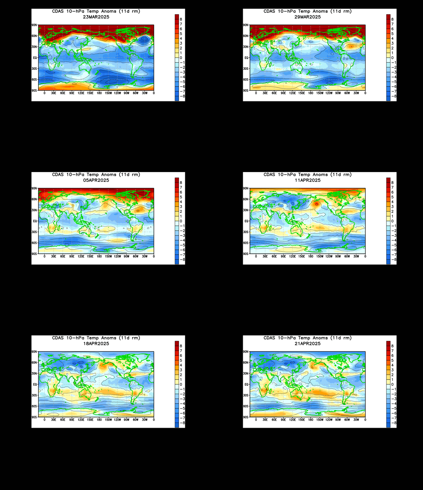
The lack of any stratospheric warming event indicates a lack of strong blocking, therefore when cold air does arrive it doesn't last long. Essentially the arctic air will hit hard for a few days then continue it's journey out to the Atlantic where it will modify and lose it's arctic characteristics.


The models do suggest some interesting weather as we head into December, and I agree. All we can do now is sit back, wait, and enjoy what "nice" weather we have left. Check back in a few days for updates.

Thursday, November 17, 2011

Thanksgiving? Could it snow?

Once again the european model has caught eye of a potential snowstorm. It's only one model and one run but this is the same model that forecasted the Halloween storm a week prior. Let's see what tomorrow brings.

Saturday, November 5, 2011

Winter Outlook 2011-2012

This winter outlook is much shorter than ones in the past because I already post a blog which I called my pre-winter forecast. That goes more into depth into the main reasons behind my thinking and you can check it out here: Pre Winter Forecast
-------------------------------------------------------------------------------------
This is the first time I have ever done a winter forecast already having a major snowstorm behind us so I will be including that event into my snowfall prediction. Let's start off with the projected winter season temperatures:

The map above does show the heart of the cold this winter over the upper mid west and great lakes region. This will result in some major lake effect snow outbreaks and a storm track that brings the snowiest conditions to the Appalachian Mountains. The early part of the winter willcome with much colder than average temperatures and above average snowfall right up to the holidays. During the heart of winter there may be prolonged periods of ridging over the east which will help to bring the average winter temp up to just below average.

Forecasted precipitation from average:

Unfortunately for Texas the drought will continue through the winter months as the northern tier gets their fair share of precip. The lakes region will end up well above average associated with the lake effect snow events.

I promised a short winter forecast this year so I don't put everyone to sleep so here is my project winter snowfall forecast for the area:

(**Just a note on snowfall. Just one snow event can drastically alter the accuracy of this map and it's not easy to forecast snowfall within a ten inch range. Last years map was bust on eastern sections mainly because of nearly 30" of snow during the post Christmas blizzard)

Wednesday, November 2, 2011

Winter Has Just Begun

Unfortunately I wasn't able to work on my winter forecast due to lack of power. I plan on getting it finish by this weekend if all goes planned. I think I've had enough snow for now but I do want to recap the storm a little and talk about a major pattern shift coming mid month.

Snow totals across the state from the October snow storm:

Basically the higher terrain got hit the hardest with the storm and most of Sussex County for that matter. I picked up 16" at my house, around 18" in West Milford, and even Central Park picked up 2.9". The totals aren't nothing compared to what we see in the winter but since the leaves have yet to drop the situation went from plowing and shoveling to all out destruction. Basically this set records for everywhere. If this had been January then the snow totals would be measured in feet.

This storm made us realized how fragile civilization really is. When the power is out basically your back in the olden days. Food went bad in refrigerators (even in stores), gas stations ran out of gas (if they had power to pump it), roads were impassable (that's an under statement), and for the first time I felt at the mercy of the weather. Some roads are still in bad shape and many residents are still without power. Stores that don't have power are losing a lot of money and employees aren't getting paid to do nothing. I even ran out of money. Without power ATM's and credit machines weren't working, forcing people to drive long distances just to get some cash out of a working machine.

Want a hot meal? Can't cook without power, and neither can Burger King or Ted's Deli. Want milk? Well the trucks can't make deliveries without fuel that was hard to come by and stores can't keep food cold without power. Want that tree off your house? Your local tree cutter isbooked for the next month. Want heat in your house? The stores are all sold out of generators and kerosene heaters. This was the most destructive storm in north Jersey I have ever seen, and may end up being the most costly of all time. We are at the mercy of mother nature and this storm was a harsh reminder of that.
------------------------------------------------------------------------------------------
Let's move on to the long range outlook. First let's take a look a the three teleconnections that affect our region the most:


As seen above the NAO and AO both take a nose dive into negative territory. This can only mean one thing, a pattern change. The NAO going negative will allow for storm to ride up the coast line and the AO will essentially displace the cold air from the pole to lower latitudes. This is will be the first real arctic outbreak of the winter season. The values go negative next week and we will allow for about a weeks lag, so around November 15th place like Mountain Creek and pretty much every resort on the east coast can turn their snowmaking systems on full blast.

One thing we want to look for is a stratospheric warming between 10mb-100mb, but I have yet to see one of any significance. Give it a week and a major event will be occurring over the western Pacific.

By the second half of this month we will be talking about snow again but by that time the leaves would have dropped from the trees so widespread damage is not likely.

Friday, October 28, 2011

Batten Down The Hatches... (Snow Map)

Let's talk snow!? First off I am much more worried about this storm than any others I have personally experienced. And that's because the leaves have not fallen off the trees yet. In fact some urban areas with exotic and invasive tree species still have green! It only takes around 2"-3" of snow to take down a tree with leaves. Now what if you get 8"-14"? And some models even suggest up to 20" in some locals (highest terrain). This is a major problem, and power outages are not just likely but certain. Here aresome tips:

-Take down any outdoor screen houses/umbrellas
-Don't park under tree limbs!
-Keep the space heater ready, if power goes out so does heat!
-If you need to keep food items cold outside works. Unless a bear comes...
-No matter your age, take breaks while shoveling. This snow is often called "cardiac snow".
-Do not walk/stand under stressed trees with foliage
-Above all, don't under estimate the storm just because it's October...

Elevation will still play a major role in this storm, but so does the exact track. I'm going to take the average liquid equivalent of all models and use that to draw my map while keeping terrain into consideration. Let's look atthe QPF maps:

NAM: (1.5"-2.00")

NMM: (2.00"-3.00"+)

GFS: (1.50"-2.50")

JMA: (2.00+)

Now that we have a good idea of precip amounts let's look at the sounding:
Above is a vertical profile of the atmosphere and the red link represent freezing. The long blue line are temp and dew point. When they come close to each other it means the air is saturated, in this case it's not clouds but HEAVY precip. If you look closely the lowest level is above freezing to start the storm. This means areas below 1,000 feet will start off as rain. Above that expect all snow from the beginning. To those of you below 1,000 don't fear, the rain falling will actually cool the surface quickly and change it over to snow. It's better known as evaporational cooling.

Let's progress to the height of the storm:
Now that's what I call a PERFECT snow sounding. No significant upper level inversions, which means no mixing! At this point in time snowfall rates could be near 2"-3" an hour! Highest elevation will be colder than lower ones, which means higher snow ratios and thus deeper snow.

Now that we cleared all that up let's look at the snow map/forecast:

Map considers these circumstances:
Most affected (Morris, Warren, Sussex, western Passaic)
-Average precip total (QPF) for entire area = 2.125"
-Snow ratio of 8:1 to 10:1 by hour 6 of event
-Surface temp tomorrow for areas <500' = 34.1
-Surface temp tomorrow for areas 500'-1,000' = 32.5
-Surface temp tomorrow for areas 1,000'-1,500'= 30.8


-Also expect gusty winds out of NE
-Thunder snow is being forecasted
-White out conditions at times


Be safe and stay classy...


P.S. What do you think of this new format for snow map blogs? Does it help with understanding the event? Comment or send email to millirod@kean.edu

Thursday, October 27, 2011

It's Snow Time!

Well, the chances of it snowing look pretty good for the area. Actually, I would say it's almost certain at this point. The european model was the first to catch onto the system and now most operational models are showing the same scenario. The only question is how much snow will fall?

Let's take a look at the latest GFS:

Essentially all models are showing this now with the exception of the NAM. It will probably catch on by the 18z run time. Basically we just need to know how much liquid precipitation is forecast and translate that into snowfall amounts. The GFS forecasts around an inch liquid for Sussex County, so that would mean around 4"-10" inches of snow! It's a large range because lower elevations *will* get less snow than the higher terrain because the temperature factor.

Take a look this sounding for Sussex County:

Any forecasts you see of rain/snow/mix are completely inaccurate. This storm will bring all snow to the area with no mixing. Nothing even suggests such a thing so I'm not sure what those forecasts are about. Anyhow, the sounding above shows there will be no warm layer inversion so it's either rain or snow. No sleet or freezing rain thank god! High temperatures forecasted by NWS are in the mid and upper 40's! That's wrong. When the precip falls (especially heavy) it will cool the atmosphere and temps will struggle to rise above 32 degrees in the higher terrain and 35 in valleys!

I still need to make a snow map. It will be out tomorrow.

P.S. It looks the rain today may end as a brief period of snow in some spots around 00z!

Tuesday, October 25, 2011

Is It Time For Snow Already?

Let's get this straight. Some computer models suggest a storm moves through Thursday and brings our area mostly rain with a potential change over on the back side for parts of Sussex County. Personally I think the precipitation will end just before the cold air advances, essentially only bringing us a chilly rain event. Now currently there are two models that suggest a second system will ride up the coast and throw nearly an inch of liquid precipitation into cold air (this includes the entire state). Let's take a look at these models:

JMA (Japanese Model):

Okay so the model above shows high winds and nearly 20" inches of snow across New Jersey, which I do not believe. This model always has an issue with predicting total QPF (total precip) but the physics in the model seems to be somewhat trustworthy. The blizzard depicted above is not very likely, but it does help support the idea of some kind of snow event.

ECMWF (European Model):

Above is the snowfall forecast for hour 105 and it's only a three hour increment. The total snowfall predicted by the EURO is 6"-10"! This model has been consistent for the past several runs, something that meteorologists look for when analyzing model output. Also the EURO is known for having better physics in the model than most others.

So far no other models have gone to this idea, instead they just pass off the storm off the Mid-Atlantic coast. As of right now it's too far out for making any kind of calls, but check back tomorrow as I will be posting on the very latest model output and give you my personal opinion.

P.S. Winter Forecast should be out by the weekend