Saturday, January 30, 2010

Yeah, it's cold

Looking out my window I see the snow covered lawn and my weather station next to me reading 13 degrees. It did not snow a flake here today but some areas to our south did see some flurries and Cape May picked up 5-8 inches of snow. And I see more coming...

The middle of the week looks to bring something in the of way snow. It may not look like much but after Thursday's bad forecast we can't be taking chances. This is a small event and could produce minor accumulations:

Secondly we have next weekend, which looks promising to say the least. It is obvious to tell that this storm will track further to the north and west, and could be our next big storm. The Euro is really going with a perfect setup:

Check back for more, February looks to bring a lot more snow than January...

Wednesday, January 27, 2010

It's go time baby

I want to start by saying I am sorry to the ones who view my blog on a regular basis. I have been slacking off, and it's not like me to do that. I want to assure you that I am back, and I plan on updating at least 2-3 times every week or as needed. I've been going through a tough time lately with things just building up but I realized I can't stop doing what I love because that will only make things worse. Remember that...

Enough of my boring rambling. Let's talk winter? First off let's look at Thursday night into early Friday morning. I can tell you now that it's going to snow, and I think most the area will see accumulation of some sort. Higher elevations towns like Hopatcong, West Milford, Mount Olive, and along High Point ridge could pick up 1-3 inches in some heavier snow squalls. I can't post a snow map on it because it's a hit or miss situation, thats how snow squalls work and it only makes them more mysterious. I'll never forget the time a few years ago when a snow squall dumped 4.5 inches of snow in Netcong in half hour while most of the neighboring towns didn't even see a flurry. (I remember how enraged my cousin in Jefferson was. Haha!) Check out the NMM model below:

As for Saturday I am sorry to say that I don't think north Jersey will even see a single flake. The storm system should go off the South Carolina coast. For those who don't know a storm system going off the Delmarva typically puts north Jersey in the "jackpot", and off Atlantic City puts the higher elevations of NW Jersey and the Poconos in the "jackpot". So it's obvious that the storm is way to far south. Here is the 18z NAM (I think it will trend more north but still miss us completely):

In the wake off the storm that went off to our south plenty of cold air will be around (the coldest of the season), which will make for great snow making conditions across the entire region. So that icy hard packed surface should turn into more of a frozen granular and PP machine groomed surface, which isn't to bad by Jersey standards. Low temps will near 0 degrees, which will probably be the coldest of the season. (If we had snow cover temperatures would easily fall into the -10 range)

Remember February and March our the snowiest months here in north Jersey. February for NE Jersey and March for NW Jersey believe it or not. The elevation plays a HUGE role in the spring time snow, just like early fall snow. And there is much more moisture that time of the year, unlike January which is typically cold and dry. Check back later in the week for updates...

Sunday, January 17, 2010

Better late then never

The storm is here and most of us can see that. I also just woke up because of my staying up late playing sim city. Anyhow for all of us this storm started out as just plain rain, although the higher elevations started off with a brief period of sleet. Even at my window perch 972 feet above sea level it's just rain, but the temperature has dropped from 35.9 to the current 32.9. This tells me the storm is generating it's own cold air, which is what I have been thinking would happen. It will go over to freezing rain, then sleet, then snow eventually once the upper air pattern cooperates.

The most recent soundings from the 12z really do not support much in the way of snow. The upper air is about a degree to warm. Now if the storm deepens more than the models are showing then we could cool off enough for accumulations. And for this reason I'm not going to make a snow map, because I can show you nothing that means the atmosphere will support snow. We also have next Friday?

Let's see what happens...

Friday, January 15, 2010

Twist?

The latest model runs that just came out about now have shifted the storm system nearly 100 miles of the path it had on the 00z and 06z runs. Could just be a bad model run? If it continues then this is a mostly a rainy system with some pockets of ice. Putting us out of the snow swath completely. Let's see what happens with the 18z runs around 6:00.

Thursday, January 14, 2010

Snow Coming...

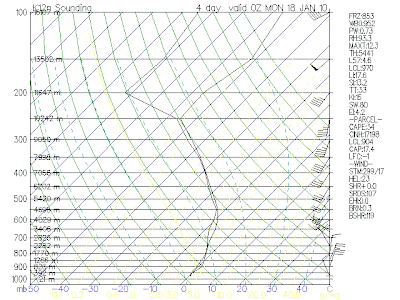
The latest sounding off the 00z runs show quick change over to snow. I can see how 4-8 inches of wet snow falls across the higher terrain and 3-6 in the valleys. Here is the sounding:

More tomorrow after I come up my final idea on the storm.

Who wants snow?


Take a look at the latest sounding. It's so close to supporting a heavy snow event. Let's get a little closer to the event then I'll post again.

Tuesday, January 12, 2010

GFS changes things up...

This blog is based just off the 00z run of the GFS because it has a completely different look then the previous runs. And it's not looking good.

First let's take a look at the surface. You can see a nice amount of precipitation moving in but cold air is not far and thickness values are low:

Now Let's look at the 850 temperatures, since they are above freezing that means it can't snow. But that doesn't mean the precipitation won't be frozen once it hits the ground :

And here is a look at the sounding. This confirms that temperature are below freezing at the surface for the majority of the storm and this could lead to freezing rain and sleet build up, and lots of it. What we need to do is get those 850 temps to cool down a bit and then it will support snow, if you like snow that is:

Sunday, January 10, 2010

Let's make it warmer?

The title of this blog makes you think. Why would he want to make things warmer outside? For one I need to get my Christmas decorations inside which are all frozen to the ground and second it's to cold and dry to get big snowstorms. In December we had a day or two of warmth separating each cold snap with snow, and it's that kind of a pattern that brings in the heavy snowfalls. Essentially its to cold to snow. So let's make it a little warmer, then things will get interesting. The following are weather events to come.

Monday Night-Tuesday:
With cold air persisting over the region a clipper will bring in a reinforcing shot of cold air, nothing harsh but just enough to keep things cold. Along with it comes the chance for snow in northwest Jersey on the order from 0"-2", but that's a hit or miss situation and elevation will play a role. The precipitation won't make it over the mountains/hills so areas south and east will have nothing but clouds, if that.

Thurs-Fri-Sat:
We will finally go above freezing these days which will not benefit the ski areas because the surface will transform into an icy hard packed variety (No me gusta). Anyhow, mild temperatures into the upper 30's and even low 40's will move through the area melting a good chunk of the soft powdery snow that has built up on the ground the past two weeks. This warm up does have a good side, and I think you will agree.

Sunday-Monday (Next week)
An area of high pressure will move down from the north bringing back the cold air (but not to cold) and a low will be coming up out of the south. The exact situation is too far out to really know what's going to happen but it seems that whatever happens will mostly likely be the snow variety across north Jersey as a whole, all I know is that the cold air will not give in this time. Here is a look at the GFS for our NEXT potential BIG storm?

After all this is said and done what happens next? Well I honestly cannot tell you. Maybe we warm up or perhaps we go back into a deep freeze. Both could be a possibility, but let's handle the appetizers first then move on to the full course meal later.

Saturday, January 9, 2010

Met office gets drilled by BBC

Check out this video about the met office. It goes to show how cold its been not only here in the US but the World wide cold that has been so persistent.

http://news.bbc.co.uk/2/hi/programmes/the_daily_politics/8443687.stm


The weather pattern is basically too cold to snow. And I mean that because we have been under a cold dry air mass which does not support a lot of snow. Later this weekend I will post a blog for the run down of changes ahead and potential storms?

Wednesday, January 6, 2010

Arctic Wave Brings Snow

This is much different than what we usually get. And in fact I'm just learning how exactly this kind of set up works. Since the precipitation is falling not in a polar air mass, but arctic. So you should expect high snow ratios 25:1 to 30:1 when our normal is 10:1. Just take a look at how this storm is looking on the models:

The models are trending more precipitation as time goes on so we could get up to .2-.3 inches of liquid, which would equal 4-8 inches of fluff. And I mean fluff. The snowfall would be fairly uniform across the area and elevation doesn't play too much of role in this case.

Friday, January 1, 2010

Lake effect squalls tonight

It's now 10:36 and been snowing heavy for about a steady hour now and this was not expected. Gusty winds are causing white out conditions ( I couldn't see my neighbors house). The precip coming across Sussex County is lifting up over the ridge from Hackettstown to West Milford and accumulations will be from 1-3 inches. It's interesting cause the radar does not show any precip over my house yet I have had a steady hour of heavy snow. The snow could last several hours tonight, and once these bands get set up they are hard to break. Roads are now covered this evening and winds are gusting around 30 mph, it should make for a good night to drink a cup of coco...

Updates

Sorry for no snow map yesterday, that's because I went snowboarding at Mountain Creek which was awesome. I would say the bottom got 2.5 inches and up top got 3-4 because of the lifting air going up over a 1,000 foot vertical. Yeah it makes a BIG difference. My forecast was calling for a grand total of 4-6 inches, but I probably should have said 3-5 because that's around what most people got with the morning and evening snow events together. And lower elevations getting less.

December:
Let's recap December because it was a cold and snowy month. Now this is for my house at 1,000 feet so some will have more and some will have less. I just want to point out that December was typical of El Nino winters. Lots of snow, then rain to melt, then snow, then rain. But that's how you get big snow seasons around here.

" Well we got a whole lot of rain 5.09" inches to be exact which was WAY above the average, and on top of that we had 22.25" inches of snow. Now that is a decent chunk but northwest Jersey averages 50"-70", so months like this need to happen to get us there. We also had white Christmas and a white New Years. In total we had 20 day's this month of solid snow cover topping out at 18" at High Point and a foot other places. It snowed 10 days this month and we stayed below freezing (for highs) 15 days. The average is 30 per season, last year we had 50! (A cold and dry winter if you ask me)". The average day time high was 5.4 degrees below average, and the over night low was 1.1 above average. (The over night almost every month is above while the daytime high is significantly below, this is most certainly due to urbanization of my area over the last 40 years. Which means the "average" is essentially useless. By personal opinion it useless everywhere because there is no "average" or "normal". But the weather offices and everyone uses it so all in all December was 2.1 degrees below the "average".


Out with the old, in with the new. JANUARY!

Now after today's warmth (mid 30's) we will dip below freezing tonight and I don't think we will get above it for a solid two weeks. The arctic oscillation (which you can find in previous posts) is heading toward a value of -6, which basically signals the cold air is here, and here to stay for awhile. The NAO is also negative, and just to let you know we have had ALL our snow this season while the NAO was negative. That includes October and all of December, but remember that warm November? It's wasn't global warming. It was the NAO and AO both positive, and there was no snow and little cold. Go figure? Now they were both negative and it was cold and snowy. The NAO, AO, ENSO, MJO, AMO, PDO, PNA, AAO, and other oscillation patterns ARE essential in weather forecasting medium to long range. If you don't fully understand these atmospheric patterns I suggest you look them up, it's fascinating stuff. It's these indices that whether decadal or not that cause short term and long term climate change. If Al Gore knew about this stuff then maybe he would claim to have invented it...

Ok, sorry for my rambling. Climate change is touchy for me, and when a politician tries to sell me something as fact it's in my scientific nature to question it. And if you don't wanna question it and just go with the "majority" then you my friend are not a scientist. You are a follower that cannot think/do for themselves. Ok, I'll make another paragraph for the 1996 repeat storm? Yeah, I just said that...

I was only a youngling when the blizzard of 1996 hit, but I remember it like it was yesterday. In fact it's why I am blogging to you right now, it is the event that lead me on the path to meteorology. Unfortunately I don't know the entire scenario that played out but Joe Bastardi is talking about a potential repeat of the storm to the DATE! This is the GFS model for January 8th, exactly 14 years after the blizzard. It's developing along the arctic front and it's our next potential snow event. I'm all over this...\

That's it for now, if there are any misspellings I'm very sorry. I don't have any time to proof read this morning, I heading out. See ya later...