Monday, December 16, 2013

Clipper System

A clipper is moving through for tomorrow morning and should make the commute a nightmare. Very simple system so there isn't too much to go into here. Snow map should explain it all.

Now by the end of the week winter will take a break for awhile and we can take a break from shoveling.... for now.

Saturday, December 14, 2013

The Snow Begins

The snow has begun to fall lightly across the area and unlike the last system will slowly begin to increase in intensity. Today is an all snow event for north Jersey, however the entire system will not be. We have a warm layer inversion moving in tonight which will melt the snow falling through the column and with temperatures still cold at the surface will refreeze back into sleet pellets before hitting the ground. Example below.


This will cut accumulations down but sleet accumulates quickly on roadways and will only create a thaw resisant blanket over the snowpack. This snow is sticking around for at least the next week.

Below is a QPF map from the GFS which has been handling the winter weather much better this year than the NAM. 

Not all of that liquid will fall as snow otherwise I would be calling for a 12+ in locations. Snow map is below and enjoy. I'm going to hit the slopes today.


P.S. More snow coming Tuesday! How much? Stay tuned....

Tuesday, December 10, 2013

Update**

The map for today's snowfall that I issued last night verifed very well. I based it directly off the GFS snow totals (the model that handled Sunday's snowfall the best). I have a new respect for the GFS and perhaps the upgrades made over the summer have something to do with it.

Speaking of GFS it shows a major snowstorm for this weekend.

I don't like making any kind of call this far out.... you can bet I'll be posting very frequently over the next few days.

Monday, December 9, 2013

More snow

Another round of snow just in time for tomorrow's commute. I did very poorly on the last forecast and I'm not going to let that happen again. The GFS was correct in reguards to precip amounts over the region and the NAM didn't perform to well. This time the GFS and NAM are on more of an agreement so this is based on QPF amounts of the storm. It's not a "major" event but the timing couldn't be worse, I suggest getting an early start tomorrow to beat the fuss. 

Snowfall map December 10th 2013:


Sunday, December 8, 2013

Update

A massive shift southward in this system has allowed for little precip to fall over northern NJ. Some areas over southern portions of the state have pick up 5"-10" of snow! Unexpected and none of the models caught on. A second round of precip will move in by early morning but by then the warmer air would have won the battle and sleet and freezing rain will be the primary form of precip till the change to rain.

Snow Is Moving In

The system that will bring us accumulating snowfall is currently over the mid atlantic this morning and heading northeast. Classic warm air advection snow when the warmer air over rides colder air and eventually wins the fight. It will start as snow in all areas and eventually turn to sleet as the warm air wins the battle in the between 900 and 800 mb.

Snow sounding from NAM after 0.25"-.50" liquid equivalent


Sleet sounding from NAM


Freezing rain to rain soundings from NAM toward end of event
 
Very simple forecast up to this point in reguards to precip type. The big question is how much snow will accumulate and where. We have a issue with the models on this as the NAM shows a swath of 3"-6" over north jersey while the GFS is shifting the heavier precip south where it will fall as a mix bringing max snow totals around 3". At this point the GFS seems to have initalized better in reguards to current conditions over the mid atlantic. 


 I feel as if a mix of the GFS and NAM would be a safe and more accurate forecast than choosing one over the other and making a critical error in forecast amounts. 

My map (not including ice amounts)
That's it for now. More snow could be on it's way in the coming days but it seems like a small event. Till then, enjoy.


Wednesday, December 4, 2013

Snow is coming...

Looks like our first widespread accumulating snowfall is on the way for the beginning of the week. A warm air advection event is in store and this typically entails warmer air invading the storm and eventually changing the precipitation over to a rain event.
The sounding and model run are both from the GFS at 114 hours out. Not the ideal set up but it looks like a good 2-4" of snow for the area with some folks seeing a little more before the change over to rain. I give this a high probability of happening as there isn't too much that could go wrong with this type of senario. 

Updates will follow as the event nears.

Sunday, December 1, 2013

Winter Forecast 2013-2014

The follow winter forecast is based on current observations and historical data and will only forecast temperatures departures for normal, snowfall percent of average, precipitation percent of average and some added forecast comments.

A. Big Picture (driving mechanisms)
     1. Arctic Sea Ice
     2. ENSO phase
     3. NAO & AO
     4. PDO & AMO
     5. QBO
B. The Checklist
C. Final Forecast
     1. Temperature anaomalies
     2. Snowfall compared to average
     3. Precipitation percent of average
------------------------------------------------------------------------------------------------------
A.  The Big Picture

1. What's better to start of with than the current sea ice extent in the arctic? This can directly linked to northern hemisphere winters by aiding in the creation of arctic air masses with more ice and more of the suns energy reflected back out into space instead of being absorbed by darker bodies (land/ocean).

The October ice extent was very impressive compared to last year and was even close to the 30 year average, a rare occurance these days. This tells us that cold air is being generated much quicker and arctic air masses will be in high supply and occur early in the season, but this alone doesn't tell us everything. We need to look at much more.


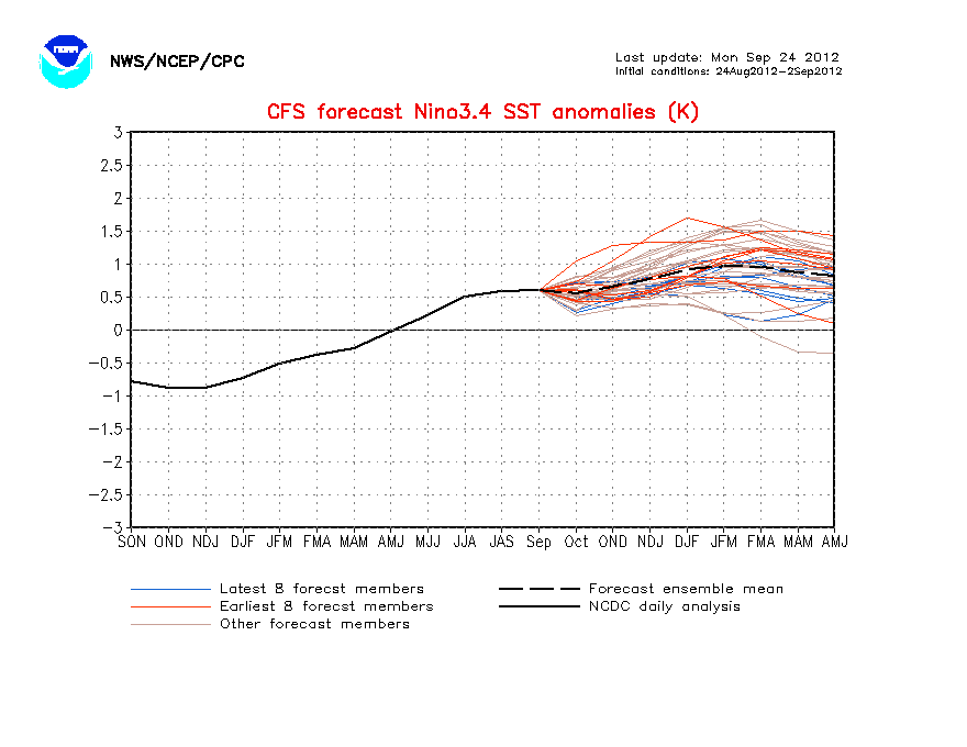
2. El Nino Southern Oscillation

Below is the sea surface anomalies for the equatorical pacific. Right now we are in a neutral (slightly positive) phase of the of the ENSO, meaning there is no El Nino nor La Nina. The neutral phase is expected to continue through the spring of 2014. A vital player in precipitation and weather patterns over North America.

3. North Atlantic Oscillation & Arctic Oscillation

Even if the arctic has a large supply of arctic air it needs to be able to reach lower latitude and it does so during certain type of "weather patterns". The NAO and AO are blocking patterns and when both phases are negative we can expect cold airmasses and storms systems to ride up the eastern seaboard. These indicies cannot be predicted more than a few days out and vary in cycles of days, weeks, months, years, and multi-decadal! Either way when these indices go negative this season (not predictable when) expect colder arctic outbreaks than in previous years. While it's not predictable when they go negative,
"? more than a few days out the NAO and AO have their strongest influence on us during the mid to late winter when wave lengths in the jet are at their peak. We look for these troughs, retrograding, and cut offs which make for some interesting weather. 

These oscillation are forecasted off the daily model output and you can find the updated charts on my model site http://darrenmilliron.com/models/climo.html or the climate prediction center http://www.cpc.ncep.noaa.gov/products/precip/CWlink/pna/nao.shtml


4. Pacific Decadal Oscillation & Atlantic Multidecadal Oscillation

The oceans make up 70% of this planet and to ignore them in forecasts would be like forgetting to set the locking arm on an extension ladder. It's just plain risky. Unlike the NAO/AO these are regular cycles of about 30 years and play a role in storm formation and temperatures. 


PDO went negative back in 2007 and has stayed there ever since. This means cooler waters off the coast of Alaska and increased snowfall over the Pac Northwest. The implications for the northeast is still somewhat unknown but cooler and dryer winters seem to be the likely trends. 

The AMO entered its warm phase in 1995 and it still stongly postive with a change not expected for another 10 years or so. This not only plays a role in our weather, but the whole northern hemisphere aiding in increasing air temperatures and melting away sea ice (the most likely cause for arctic sea ice loss in the past 20 years). For this reason I don't expect record breaking cold across the northern hemisphere, something to just keep in mind for the next decade. 

5. The Quasi-Biennial Oscillation (QBO)

Every two to three years the winds over the equatorial stratosphere shift directions from easterlies to westerlies. This is called the QBO to keep it simple. The QBO shifted positive or "westerlies" in March of 2013 which means stratospheric warming over the arctic will be at a MINIMUM. This means blocking patterns such as NAO and AO may be primarily postive this winter. Not good for snow lovers. The QBO is still in a fairly weak westerly phase so maybe we will still some chance, but each month the westerlies grow stronger. 

----------------------------------------------------------------------------------------------------

B. The Checklist (red=bad for snow lovers / blue=bad for snow haters / black= equal chances)

-QBO (westerly-postive)
-NAO (postive influence by QBO)
-AO (postive influence by QBO)
-AMO (warm phase)
-PDO (cold phase)
-Solar cycle (very weak) 
-Neutral ENSO
-Arctic Sea Ice extent
-------------------------------------------------------------------------------------------------------

C. The Forecast

1. Temperature Anaomalies

With the evidence at hand I put the coldest temperature (with respect to average) over the central US where some very cold arctic outbreaks will occur but modify as they come east. The SW and SE will end up a little warmer than average but that doesn't mean winter will be a bust in these locations. Temperatures don't represent season snowfalls and snowy winters can occur during warming winter and the opposite with cold winters.

2. Snowfall Compared To Average

The map isn't very detailed and shows average snowfall for the northeast but increased snowfall over the NW and over the lakes do to the arctic outbreaks which will cause a good deal of lake effect snow this season. Now just one storm and make or break this map in the northeast and it's a safe bet to say average snowfall with a lessened chance of blocking patterns setting up but with plenty of cold for some systems to tap into just west.

3. Liquid Precipitation Percent of Average

Now looking at my own forecast as a snowboarder I realize it's not the best outlook. This winter will have plenty of cold air in stock and the majority of our snow will come with frontal systems, clippers, or warm air advection systems. With blocking at a minimum this year Nor' Easters will have issues laying down the white along the I-95 corridor but during times where blocking is in place these storms could work their magic. Overall by the time April rolls around, we will be able to look back at winter and realize it gave us our fair share of pro and cons. In my eyes it's pretty much an average looking winter in store and I'm ready. Are you?

Tuesday, November 26, 2013

We have some icing in the higher terrain this evening. Temperatures are slowly rising so it will change to plain rain by 10:00pm tonight. Please be careful on the roadways! 


Monday, November 25, 2013

Will It Snow?

Many are wondering what is going on with this holiday Nor' Easter. First off this is primarily a rain event for New Jersey. The system will start off a brief mix for North Jersey but the warmer air will quickly move up the warm side of the low pressure.

Below is a sounding for the onset of the storm. The atmosphere at this point is showing a brief period of snow/sleet but in the next 3 hours warmer air turns the precip over to plain rain. Some areas could pick up a coating of snow before the rain washes it away.

After the snow rain will be heavy at times with amounts of 1.5" - 3.0"! This is great news for us as we are currently in drought conditions. This system will be enough to even cause some flooding issues for the usual low lying areas. 

Now some are claiming that snow could sweep in on the back side of the system, which I do NOT agree with. The sounding below shows that as soon as the temperature profile is good for snow the moisture just isn't there, meaning the precipitation has moved out of the area. 

For you snow lovers, this isn't your storm but don't worry. Winter has yet to even start. Check back this weekend for my winter forecast which I'm in the final stages of production. 

Thursday, September 19, 2013

Winter ENSO Outlook


Taking a quick look at the El Nino Southern Oscillation outlook for the winter season and it seems like we will have a weak to moderate El Nino in the Pacific which typically means increased precipitation for the region. Yet another signal that's making me very concerned for this winter.
Last year I forecasted an average winter season in respect to snowfall and temperatures and it came out to be a decent prediction. There have been years where I was wrong, last season was not one of them and I like to believe that I'm gaining more knowledge with the years. At this point the winter season looks to be below average temperature wise and above average snowfall. Of course I have a lot more work to do before I can say anymore.

Get those shovels ready...

Monday, September 16, 2013

What are the poles doing?

Just a quick update about the sea ice. The Arctic Ocean has reached it's minimum sea ice for the summer and made a remarkable rebound from last summer in extent and thickness.


What does this mean for our winter? Well, it's still hard to tell. Many different factors go into a winter forecast but with the current ice extent it would increase the odds for a colder snowier winter in the northern hemisphere (not region specific).

Now looking at the Antarctic ice extent we can see clearly that over the last 30 years it's been growing and still holding very strong despite theories of global warming.


While my confidence in the winter forecast is becoming slightly clearer, it's going to be another month before I issue any kind of preliminary monthly forecasts.

*All images from http://arctic.atmos.uiuc.edu/cryosphere/

Thursday, August 22, 2013

North Jersey Weather is back.....

North Jersey Weather Outlook is back, and it's not just about the weather anymore. Weather, environmental  issues, state of the climate, and even fishing and hiking articles (weather related of course) will frequent the news feeds.

Today I just want to share a video which I have found fascinating about restoring a New Jersey river back into the thriving ecosystem it once was.

http://vimeo.com/72642758

Till next time, keep it classy NJ!

Sunday, February 3, 2013

Possible bigger storm?

This is off the euro for this Friday. Shows a potential coastal low pressure system that could bring snow to the area. Chances seem low at this point but it's something to watch. Other than this small systems will  move through during the week bringing light accumulations, but nothing major.


Sunday, January 27, 2013

UPDATE ON TOMORROWS EVENT:

As predicted the cold air will hang in longer at the surface causing a wintry mix of precipitation to occur over the area. Snow, to sleet, to freezing rain, and maybe a little drizzle toward the end. Accumulations will be light as this system doesn't have a lot of moisture associated with it. Around 1" for most areas north of I-80 with a thin coating of ice to cap it off. Here is a look at the forecasted snow totals of the RPM

Now there is the chance some heavier bands over PA could make there way into Jersey and could surprise us with an extra inch or so. It's a small event but timing is horrible occurring from morning rush to evening rush hours.

Thursday, January 24, 2013

With all this frigid arctic air around one would think a good storm will eventually materialize. Earlier this week it looked like Friday would bring a plowable snowfall but that is no longer in the cards. The most recent models show almost no snow accumulation at all.

The map above is off the latest RPM and it really doesn't show much more than flurries for most the state. I do think areas of south Jersey could see a little more than this but this storm really isn't something to concern yourself with. Not exactly good news if your skier or snowboarder (like me).

Now, while this may be upsetting think of how much snow the resorts have made over the week and it will allow rapid expansion of terrain, packed powder surface conditions, and more features to built in the parks. The snowmaking window will leave us Monday when temperatures rise into the lower 30's and humidity levels rise, but I think this brings us a shot at some wintry weather.

Here is a look at the GFS for Monday:

This type of event typically starts off as snow, changes to sleet, then freezing rain, and eventually ends as plain rain. If we look at the sounding for Monday you can see the cold air at the surface with a warm air inversion around 850mb producing sleet for us here at the surface.

I think this storm has a greater potential for accumulation, perhaps a few inches. Updates will be posted this weekend.