Wednesday, December 30, 2009
Some snow for New Years
A storm will come up from the south and brush over the area bring a complete snow event to northwest Jersey (No Mixing). Higher elevations will get more than the lower elevations because the temperature could hover around freezing. As of right now it's looking like 4-6 inches, check back tomorrow morning for a snow map.


Sunday, December 27, 2009

Friday, December 25, 2009
Arctic Oscillation Spells Trouble
The latest AO forecast is off the charts. Since I have been into the weather I have never seen it go off the charts, and for so long. This signals one thing, extreme cold. When the AO is negative it means the cold air over the poles is easily transported to lower latitudes, and it's not polar air it's pure arctic air. To me this is a precursor of nasty times ahead.
This coupled with a negative NAO sends all the cold air into our region. After this winter I don't want to hear a thing about global warming, and neither will you. Check it out, it's almost unreal.
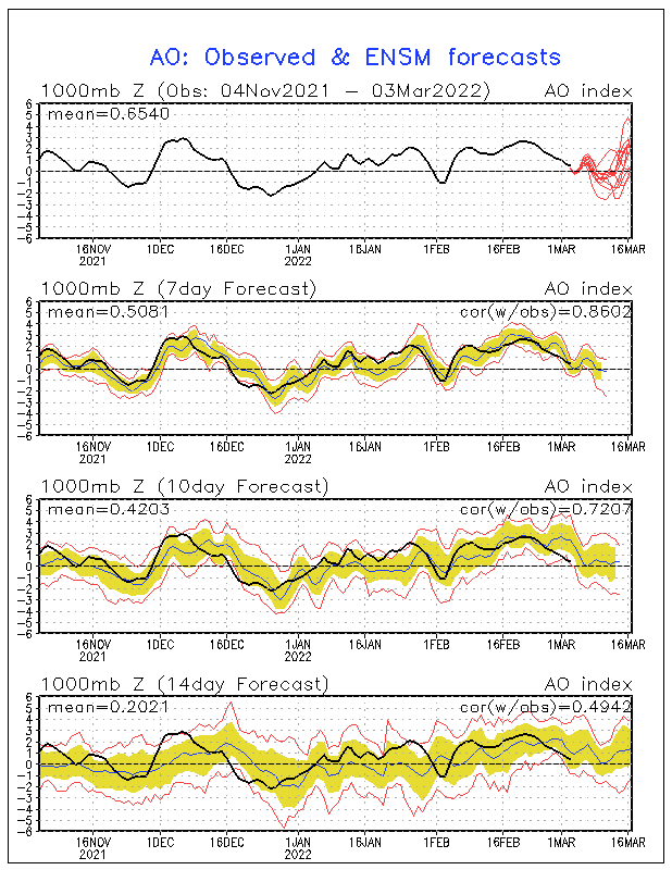
This intense blocking pattern over the arctic circle could be due to volcanic activity injecting sulfur into the stratosphere warming it which in turn cools the troposphere. The basis behind the AO! But that's only theory...
P.S I ended my below freezing streak with 225 hours and 32 minutes consecutive. (Not bad for December)
Thursday, December 24, 2009
Winter is just starting...
It's been 204 hours and 6 minutes since my weather station has recorded above freezing temperatures. Today will mark day 12 this month without getting above freezing but should be the end, for now. Most places in New Jersey have received around 2 feet of snow so far this season putting most areas from central Jersey and south ABOVE average for the entire season! It's day 19 of consecutive snow cover over northwest Jersey and the entire state will have a white Christmas, which hasn't happened in a long time. Philly, DC, Atlantic City, Baltimore, and most of the south is now at or significantly above seasonal snowfall. Resorts like Mountain Creek have been able to open terrain like it's their job. Four peaks in a week and two days at Creek? That's never happened in all my years and they should be in full operation by New Years, which is just mind boggling. The nation is now facing it's third blizzard in two weeks, and in Europe over 80 people have died from the extreme cold. Guess what. Extreme cold is coming next week and it's going to smash the records that have been around for 150 years. And you know what? Winter just started 3 days ago..

It's on folks...
P.S. Christmas Storm looks icy but look what is on the maps for New Years, the nations 4th blizzard in three weeks?
Saturday, December 19, 2009
From Vermont
Well I'm in Vermont, and it's currently -2 degrees here in Rutland. Anyway I have very limited resources considering I'm on my cell phone so I can't do a snow map. But I can attach picutures so here it goes:
Case 1: Storm slides south (just by 30 miles) this means we get 2-4 inches

Case 2: Storm rides on "current path" and we get 4-8 inches with less north

Case 3: Storm comes 30 west of current track and we get 10-14 inches
Lets go with the 4-8 inches to be safe, but small changes either way will drastically change the situation. It's interesting... places in South Jersey might get up to two feet!
Case 1: Storm slides south (just by 30 miles) this means we get 2-4 inches

Case 2: Storm rides on "current path" and we get 4-8 inches with less north

Case 3: Storm comes 30 west of current track and we get 10-14 inches

Lets go with the 4-8 inches to be safe, but small changes either way will drastically change the situation. It's interesting... places in South Jersey might get up to two feet!
Thursday, December 17, 2009
Blizzard on Sunday?
The NAM is really going all out with this storm, and as of now it's the only one. As of right now the model is predicting 18"-24" inches with spots of 30". Could this be true? "Winds of 35 mph for three hours or longer with reduced visibility below 1/4 mile and moderate to heavy snow", is the definition of a blizzard and what the model shows is exactly that. Check back tomorrow morning, I'll post again before I head out for Vermont.
Saturday, December 12, 2009
Seven day for Mountain Creek
Well, I thought it would be a good idea to issue forecasts for Mountain Creek to see when snowmaking will resume and when natural snow will come again. As of now it looks like we won't see an accumulating snow event until possibly next Saturday, but it's still WAY to far out to confirm that.
Subscribe to:
Posts (Atom)


 Posts


